Williams Pass in Colorado is for experienced drivers only
Williams Pass is a high mountain pass at an elevation of 3.593m (11,788ft) above sea level located in the U.S. state of Colorado. It’s only open a few weeks a year.
Where is Williams Pass in Colorado?
The pass is located just outside of the ghost town of Hancock, on the boundary between Chaffee and Gunnison counties, in the central part of Colorado, on the border of San Isabel and Gunnison National Forests.
When was the road through Williams Pass in Colorado built?
Running through a pristine alpine meadow, the road follows an old 1880s toll road.
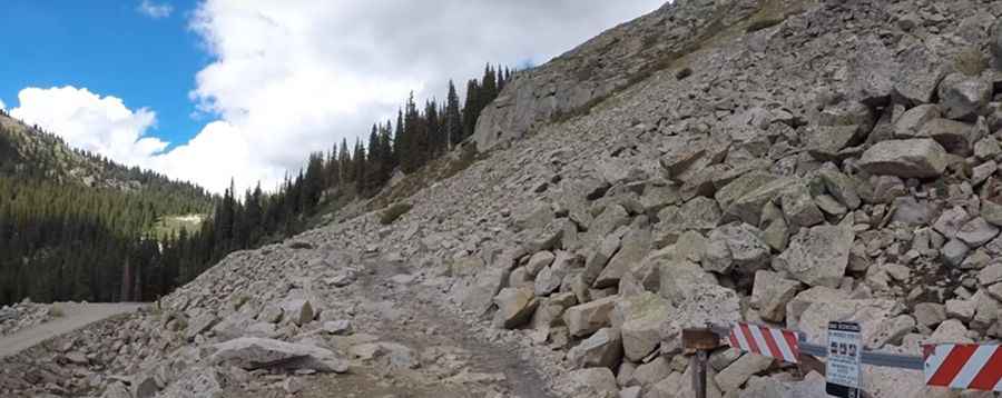
Is Williams Pass in Colorado unpaved?
The road to the summit is totally unpaved. It’s called Williams Pass Jeep Trail (NFST #298). It’s a narrow, rocky trail with mud bogs in spots. The bumpy road is very challenging: it is very rocky and very tight in the trees and shrubs.
How long is the road through Williams Pass in Colorado?
It is about 8 km (5 miles) long, running south to north from the Alpine Tunnel National Forest System Road #839 (NFSR) to the Continental Divide onto NFSR #295. The road is very steep and hits a maximum gradient of 8%.
Is Williams Pass in Colorado open?
4x4 vehicles with high clearance only. After rains, trail conditions can be too wet and muddy for safe travel. The road was closed for 12 years and reopened again in 1997, though it is only open for the month of August each year (weather permitting). Some years it doesn’t open at all. Make sure not to plan a visit during the closed season (most of the year) to avoid a wasted trip and some major disappointment.
Pic&video: madbritwillys56