Cameron Mountain Pass: Driving the Ute Trail in Colorado
Cameron Mountain Pass is a high-altitude mountain gap reaching an elevation of 3,030m (9,940ft) above sea level in Chaffee County, Colorado. Situated within the rugged landscape of the central Rockies, the pass is accessed via County Road 175, also known as the Ute Trail. This is a historic unpaved transit that serves as a technical link through the high country, where the combination of loose gravel, rocky outcrops, and volatile weather defines the driving experience for any 4WD expedition.
| Road facts: Cameron Mountain Pass | |
|---|---|
| Location | Chaffee County, Colorado (USA) |
| Max Elevation | 3,030m (9,940ft) |
| Length | 16.0 miles (25.7 km) |
| Surface | Gravel / 4WD Track (CR 175) |
How challenging is the 16-mile climb from Salida to Cameron Mountain Pass?
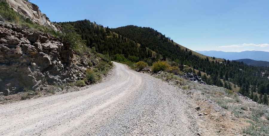
The journey to the summit begins in the town of Salida and covers 16 miles of increasingly technical unpaved terrain. The challenge of this route is the surface variety; the Ute Trail starts as a manageable gravel road but quickly transforms into a rocky 4WD track as it gains elevation toward the 3,030m pass. Navigating these sections requires a high-clearance vehicle to avoid undercarriage damage from the embedded rocks and deep ruts that characterize the upper miles. The track is narrow in several parts, meaning that encountering oncoming traffic requires a slow, calculated maneuver to find a safe passing spot on the loose mountain soil.
Why is the Ute Trail (CR 175) closed from November to April?
At an elevation of nearly 10,000 feet, Cameron Mountain Pass is subject to the heavy snowpacks of the Colorado Rockies. The road is strictly seasonal and remains closed from November to April, as the accumulation of snow makes the track completely impassable for wheeled vehicles. Even during the open months, sudden summer thunderstorms can turn the dry red dirt into a slippery mud slide in minutes. Flash floods are a constant risk in Chaffee County, frequently washing debris onto the driving line and exposing sharp stones that can easily compromise tire sidewall integrity if not approached with caution.
What are the hazards of the rocky sections near the summit?
The geography around Cameron Mountain Pass is defined by its rugged, high-desert-to-mountain transition. The road is particularly rocky in the final miles, where the gradient increases and the traction becomes more deceptive. Without a high-clearance 4x4, the risk of bottoming out on a rocky ledge is high. The lack of safety barriers and the presence of steep drops on the unprotected shoulders mean that maintaining a disciplined velocity is vital. Descending from the 3,030m summit requires careful management of the vehicle’s weight; relying only on the foot brake over the 16-mile return to Salida will lead to overheating. Using engine braking is the only safe way to descend the technical unpaved ramps.
What mechanical preparation is needed for the Chaffee County high country?
Driving the 16 miles to Cameron Mountain Pass is a task that demands mechanical self-sufficiency in a remote mountain environment. Before leaving the asphalt, a full audit of your vehicle’s tires and cooling system is mandatory. The constant vibration from the washboard gravel and the impacts from the rocky surface can rattle components loose and stress the suspension. Carrying a full-sized spare tire, extra fuel, and recovery gear is essential, as cell coverage is non-existent in many of the deeper canyons along the Ute Trail. Ensure your vehicle is equipped with undercarriage protection to handle the large stones that characterize this classic Colorado high-mountain transit.
Pic: Jonathan Bowers