California Route 39 is closed due to persistent landslides
California State Route 39 is a winding mountain road located on the boundary between Orange and Los Angeles counties, in the U.S. state of California. The northerly portion of the road, also known as San Gabriel Canyon Road, has been closed since 1978.
Where does California State Route 39 start and end?
Set high in the San Gabriel Mountains of California, State Route 39 (SR 39) is completely paved and features steep and curvy sections. It spans 80.495 km (50 miles), running from Pacific Coast Highway (SR 1) to Islip Saddle on Angeles Crest Highway (SR 2).
Where was Fast and Furious: Tokyo Drift filmed?
The road was used for the final race in the film Fast and Furious: Tokyo Drift.
What happened to California Highway 39?
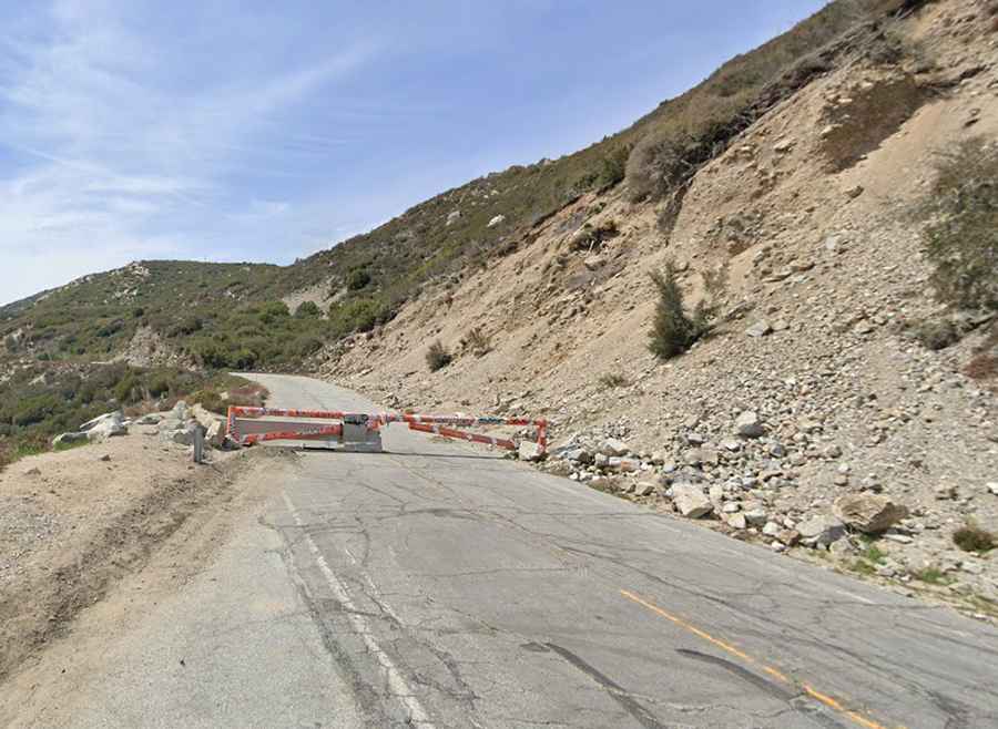
Planned in the 1930s as a vital link between coastal regions and the San Gabriel Mountains, the road, nicknamed California's Forbidden Highway or California's Forgotten Highway, was completed in the early 1960s. However, the northern section of the road—the last 9.65km (6 miles) running from Snow Springs north of Azusa to SR 2 at Islip Saddle—was closed to the public in 1978 due to a massive mud and rockslide. Environmental concerns, financial constraints, and the devastating effects of natural disasters such as landslides and floods led to portions of the highway being gradually abandoned. This abandonment resulted in its closure and eventual removal from the state highway system. Another rockslide in 2005 damaged more of the remaining roadbed. Consequently, the road was closed indefinitely to automobile traffic due to persistent landslides along its route.
Can I drive on California Highway 39?
Route 39 is one of the more varied state highways in the Los Angeles area, but portions of the road are partially covered in dirt or badly eroded. It is passable by foot or bike, as major sections are completely washed out down the west side of Mount Islip into the canyon below. The area seasonally experiences extreme snow levels, avalanches, and rock slides. Repairing the road would cost a total of $100 million USD. While the road is passable to emergency vehicles for its entire closed length, sections near recurring rock slides become narrow dirt roads unsuitable for passenger vehicles. Local geology and slope instability continue to impede necessary water flow and cause extreme flooding of the roadway at times. Despite its closure, remnants of this once bustling road remain, evoking a sense of nostalgia and curiosity among adventurous explorers and historians eager to uncover the faded echoes of California's transportation history.