The 32 Best Death Valley Backcountry Roads
Straddling the border between California and Nevada, in the USA, the Death Valley National Park is the hottest, driest, and lowest National Park. In this below-sea-level basin, steady drought and record summer heat make Death Valley a land of extremes.
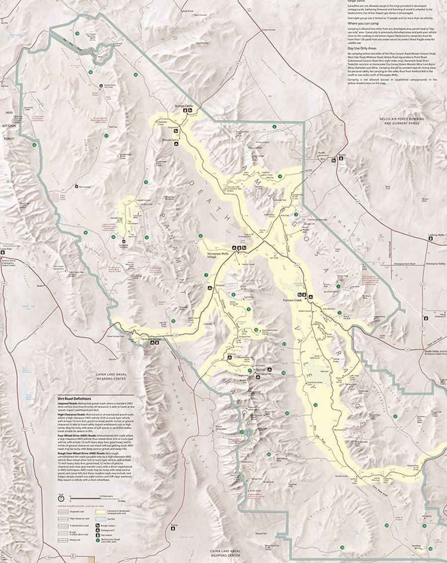
A vehicle with high-clearance will be necessary for all of the roads described below, but four wheel-drive may also be required on some of the rougher roads.
1 Echo Canyon Road
Vehicle needed: High-clearance first three miles, 4WD required beyond.
Distance: Ten miles to Inyo Mine.
Start: Hwy 190, two miles east of Furnace Creek Inn.
2 Hole in the Wall Road
Vehicle needed: High-clearance first four miles to the Hole-in-the-Wall, then 4WD the next two miles to the road’s end due to deep gravel and rocks.
Distance: Six miles.
Start: Hwy 190, 5.7 miles east of Furnace Creek Inn.
3 Chloride City Road
Vehicle needed: High-clearance first 2.2 miles to Monarch Canyon spur road, then 4WD required next three miles due to steep, rutted sections. 4WD needed on the two mile spur into Chloride City. High-clearance on final segment of the loop in Amargosa Valley.
Distance: 6.2 miles to Chloride City, 7.4 miles to Chloride Cliff.
Start: Daylight Pass Road, 3.4 miles east of Hells gate.
4 Titus Canyon Road
Vehicle needed: High-clearance due to steep grades, deep gravel and ruts. Often closed due to flood damage, mud or snow. No RVs, campers or trailers.
Distance: 26.8 miles.
Start: NV Hwy 374 (Daylight Pass Road), 2.7 miles east of park boundary.
5 Phinney Canyon Road
Vehicle needed: High-clearance first 15 miles off Hwy 95, then 4WD the last three miles. 4WD section is very steep, narrow and rutted in places. Impassable in winter due to deep snow. Strozzi Ranch Road is a dead-end spur road that requires 4WD on the last three miles due to sections of sand.
Distance: 21 miles.
Start: NV Hwy 95, 11.8 miles north of Beatty.
6 Cottonwood Canyon Road
Vehicle needed: High-clearance on first eight miles due to sand, washboard and rocks. 4WD necessary after the road drops into the wash due to deep gravel and large rocks. Final 1.5 miles often washed out.
Distance: 17.7 miles.
Start: Stovepipe Wells Campground.
7 Lemoigne Canyon Road
Vehicle needed: 4WD. Very rutted, crossing numerous gullies. The old road up the canyon is closed beyond the 4.4 mile point.
Distance: 4.4 miles.
Start: Hwy 190, six miles west of Stovepipe Wells Village.
8 Tucki Mine Road
Vehicle needed: 4WD due to large rocks, deep gravel and several dry falls three to four feet high.
Distance: 10 miles.
Start: Emigrant Canyon Road (to Wildrose) 1.5 miles south of Hwy 190.
9 Skidoo Road
Vehicle needed: High-clearance. Steep grade with protruding rocks at 3.5 miles. Sedans risk undercarriage damage. Subject to snow and mud conditions.
Distance: 7 miles.
Start: Emigrant Canyon Road (to Wildrose) 9.4 miles south of Hwy 190.
10 Aguereberry Point Road
Vehicle needed: High-clearance due to rock outcrop in road at 3.5 miles and steep, rocky final 0.5 mile to viewpoint. Sedans may risk undercarriage damage. Subject to snow and mud conditions.
Distance: 6.3 miles.
Start: Emigrant Canyon Road (to Wildrose) 11.8 miles south of Hwy 190.
11 Charcoal Kilns / Mahogany Flat Road
Vehicle needed: Most vehicles on unpaved road section to kilns, then high-clearance on final 1.6 miles to Mahogany Flat. 4WD may be necessary beyond Thorndike Campground due to steep sections and ruts. No RVs or trailers. Expect snow and ice during winter and spring.
Distance: pavement ends 5 miles, 7 miles to kilns, 8.7 to Mahogany Flat.
Start: Wildrose Campground.
12 Lake Hill Road (Big Four Mine)
Vehicle needed: High-clearance first five miles off Hwy 190, then 4WD for washed out section to mine site.
Distance: 5 miles.
Start: Hwy 190, 4.5 miles east of Panamint Springs Resort.
13 Racetrack Valley Road
Vehicle needed: High-clearance due to loose gravel, washboard and rocks. Flat tires are common on this road so be sure your full-sized spare is infl ated, all parts of your jack are on hand and tire tread is good. May require 4WD due to changing road conditions and irregular maintenance, so check postings.
Distance: 28 miles to The Racetrack.
Start: Ubehebe Crater Road
14 Lippincott Road
Vehicle needed: Rough 4WD. Very steep, narrow, and winding with cliff edge washouts. Uphill traffi c has right of way. Lower part has very narrow section that is difficult for wide vehicles. Subject to closure after washouts from heavy rains.
Distance: 5.9 miles.
Start: 3.5 miles south of the Racetrack.
15 Hidden Valley Road
Vehicle needed: High-clearance due to washboard, patches of deep dust, rocks and dips. Subject to flooding, mud and standing water after rains. White Top Mountain Road is a 4WD spur road starting just south of Lost Burro Gap that should be avoided when wet or snow covered.
Distance: 3.2 miles to White Top Mtn. Road and 13 miles to base of Hunter Mountain.
Start: Teakettle Junction on Racetrack Valley Road.
16 Saline Valley Road South Pass Section (Hwy 190 to Warm Springs junction)
Vehicle needed: High-clearance. Maintained dirt road. Section from Hwy 190 to Lee Flat has been surfaced for eight miles but is very potholed. From South Pass through Grapevine Canyon the road can be rocky and rutted. May be closed in winter due to snow or ice. Expect washboard.
Distance: 46 miles.
Start: Hwy 190 just outside west park boundary.
17 Steel Pass Road
Vehicle needed: Rough 4WD. Experienced 4WD drivers only. Vehicles must be able to climb narrow, sharp dry falls. Sidewall cuts to tires are common so carry multiple spares. No legal spur roads. Travel is easier from north to south.
Distance: 29 miles.
Start: Warm Springs in Saline Valley or Eureka Dunes in Eureka Valley.
18 South Eureka Valley Road
Vehicle needed: High-clearance to Eureka Dunes. Deep sand near dunes. Beyond the dunes the road becomes Rough 4WD and is called the Steel Pass Road.
Distance: 9.6 miles.
Start: Big Pine/Death Valley Road, 33.2 miles north of Ubehebe Crater
19 North Eureka Valley Road
Vehicle needed: High-clearance. Eight miles of dirt and gravel road to park boundary. 4WD often required to continue to Hwy 168.
Distance: 28 miles.
Start: Big Pine/Death Valley Road, 0.7 miles west of South Eureka Valley Rd.
20 Big Pine Death Valley Road
Vehicle needed: High-clearance. Expect dust, heavy washboard and occasional rough spots. The final section from Eureka Valley west to Hwy 168 is paved. Carry chains in winter.
Distance: 72 miles.
Start: Ubehebe Crater Road or Big Pine, CA on Hwy 395.
21 Greenwater Valley Road
Vehicle needed: High-clearance.
Distance: 28 miles.
Start: Dantes View Road from the north or Hwy 178 from the south.
22 West Side Road
Vehicle needed: High-clearance due to washboard, deep gravel and dust pockets. Amargosa River crossing at southern end may be impassable when flowing.
Distance: 37 miles.
Start: Badwater Road six miles south of Hwy 190 (north entrance) or 39.2 miles south of Hwy 190 (south entrance).
23 Trail Canyon Road
Vehicle needed: High-clearance first four miles to top of the alluvial fan, then 4WD beyond. Passage is slow going with many large rocks.
Distance: 10.4 miles.
Start: West Side Road, 6.3 miles via north entrance.
24 Hanaupah Canyon Road
Vehicle needed: High-clearance first five miles to top of alluvial fan, then 4WD to end of road due to very rocky and rough conditions.
Distance: 8 miles.
Start: West Side Road, 11.9 miles via north entrance.
25 Johnson Canyon Road
Vehicle needed: High-clearance first six miles to mouth of canyon, then 4WD the last four miles in the rocky wash. Last 0.1 mile of road is overgrown and very wet.
Distance: 10 miles.
Start: West Side Road, 21.9 miles via north entrance.
26 Warm Springs Canyon Road
Vehicle needed: High-clearance first ten miles to Warm Springs Talc mine and camp, then 4WD to Butte Valley due to deep ruts and rocky areas.
Distance: 20.4 miles to Butte Valley.
Start: West Side Road, 3 miles via south entrance.
27 Pleasant Canyon Road
Vehicle needed: Rough 4WD. Washouts and large boulders. Narrow, rocky road for experienced 4WD drivers only.
Distance: 12 miles to South Park.
Start: Ballarat
28 Harry Wade Road
Vehicle needed: High-clearance most of the time but 4WD when the Amargosa river is fl owing. Muddy areas develop quickly during times of heavy rainfall.
Distance: 31.5 miles.
Start: Badwater Road, two miles south of Ashford Mill.
29 Owl Hole Spring Road
Vehicle needed: First nine miles high-clearance, then becomes 4WD.
Distance: 30.5 miles.
Start: Harry Wade Road, 19.1 miles south of Badwater Road.
30 Saratoga Spring Road
Vehicle needed: High-clearance. Washboard and possible muddy areas. Amargosa River crossing will be 4WD or impassable when the river is flowing.
Distance: 4 miles.
Start: Harry Wade Road, 25.7 miles south of Badwater Road or 5.8 miles west of Hwy 127.
31 Ibex Spring Road
Vehicle needed: High-clearance first 2.8 miles, then 4WD to the spring. Road turns off Hwy 127 south of Ibex Pass. Ibex Valley Road provides a connection to Saratoga Spring Road. Loose gravel and deep sand makes 4WD with a low gear a must.
Distance: 5.3 miles.
Start: Hwy 127, 1.9 miles south of Ibex Pass
32 Deadman Pass Road
Vehicle needed: High-clearance to the pass, then 4WD to the highway due to deep, loose gravel.
Distance: 13.6 miles.
Start: 18.2 miles south of Dante’s View Road.