Burr Trail is an unforgettable scenic drive in Utah
Burr Trail is a very scenic drive in the US state of Utah. Although in dry weather it's easily accessible to passenger cars, wet weather may make the road impassable even for 4WD vehicles. It’s one of the famous hairpinned roads in the world.
Where is Burr Trail?
The scenic Burr Trail Scenic Backway runs on the boundary of Kane and Garfield counties, in the south-central part of Utah, within Glen Canyon National Recreation Area, Capitol Reef National Park, and Grand Staircase-Escalante National Monument.
How long is Burr Trail Utah?
The road is 106km (66.2 miles) long, running from Bullfrog (Highway 276), at the north end of Lake Powell, to the mountain town of Boulder (Utah Scenic Byway 12). It is typically quiet, with little or no traffic.
How much of Burr Trail is paved?
The road has paved and gravel parts. From Boulder to the west boundary of Capitol Reef, the road is fully paved. Inside the park, it remains a graded dirt road, which can be very washboarded and rough in parts. Get gas before you drive it (in Bullfrog, Ticaboo, or Boulder).
Is Burr Trail Road scary?
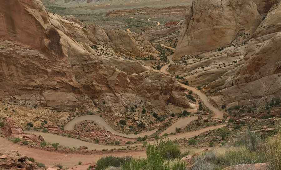
Originally a cattle trail, the route is named after John Atlantic Burr (a 19th-century Mormon settler). The road can be pretty challenging in bad weather. Although from spring to fall during dry conditions it is easily navigable by passenger cars, wet weather may make the road impassable even for 4WD vehicles. Check with rangers or local officials for weather and road conditions. Be sure to pack plenty of water and the supplies you’ll need for the trip, because despite the road’s beauty, it’s fairly remote and access to cell phone service is unlikely. One of the highlights of the trip is the Burr Trail Switchbacks, a very steep series of switchbacks over the far side of the Waterpocket Fold that may be quite testing for some, rising some 800 feet (244 m) in only one-half mile (0.8 km).
When is the best time to drive the Burr Trail?
Spring and fall are ideal times to explore this area. Temperatures are mild and hiking is pleasant. Daytime temperatures can become very hot during summer. Winter days are often mild. There are many dispersed camping areas along the road. It’s one of the best drives of Capitol Reef National Park.
Is the Burr Trail open?
The road is open year-round. But wet weather can close this road during any month of the year. Flash floods happen in an instant here. A storm can appear out of nowhere, sending water flooding into a canyon. Recreational vehicles and trailers are not recommended.
How long does it take to drive the Burr Trail?
Plan about 2.5 to 3 hours to complete the drive without any stop. However, the drive will take longer as the entire route is very scenic. It passes through the painted rock country of Glen Canyon National Recreation Area, Capitol Reef National Park, and Grand Staircase-Escalante National Monument land. It takes the traveler into some of Utah's most beautiful and extraordinary country. It affords extraordinary views of the Henry Mountains and lower Capital Reef country. It provides access to incredible hikes in contorted landscapes like The Gulch, The Circle Cliffs, and the Waterpocket Fold. Views of the Henry Mountains, the colorfully contorted Waterpocket Fold, red Circle Cliffs, and Long Canyon all await the traveler who wishes to drive this interesting back road. Numerous hikes and side trips are available for those with the time and inclination.
Pic: Kevin Matejovsky