How Google Maps Uncovered a 9-Year-Old Mystery
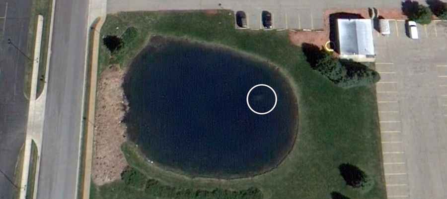
The intersection of digital cartography and forensic investigation reached a turning point with the case of Davie Lee Niles. Missing since October 11, 2006, after leaving a local establishment in Byron Township, Michigan, Niles’ disappearance remained an unsolved cold case for nearly a decade. Ironically, the key evidence—a submerged vehicle—had been publicly accessible via satellite imagery for years before being identified by the human eye.
| Case Profile: The Byron Center Discovery | |
|---|---|
| Subject | Davie Lee Niles (Disappeared 2006) |
| Detection Method | Satellite Imagery (Google Maps) / Visual Confirmation |
| Location | Submerged pond near Byron Center, Michigan |
| Time to Discovery | 9 Years |
The Discovery: From Digital Pixels to Physical Reality
The breakthrough occurred in 2015 during routine holiday maintenance outside the Cook Funeral Home in Byron Center. Brian Houseman, operating a mechanical lift, noticed the silhouette of a vehicle at the bottom of a nearby retention pond. Upon checking the coordinates on Google Maps, it became evident that the vehicle’s outline had been captured by satellite passes for several years, hidden in plain sight due to water clarity and overhead angles.
Forensic Context and Vehicle Recovery
Upon recovery, investigators found the remains of Davie Lee Niles inside the sunken vehicle. At the time of his disappearance at age 72, Niles had been dealing with significant health challenges. The case highlights a growing trend in modern search-and-rescue: the use of high-resolution satellite data to identify "anomalies" in bodies of water that are otherwise overlooked during ground-level searches.
Technology as a Tool for Cold Cases
The Niles case is not an isolated incident. Across the United States, several missing person cases have been resolved by "armchair detectives" and professionals using historical satellite imagery to spot submerged infrastructure or vehicles. These discoveries emphasize the importance of retrospective data analysis in forensic investigations—where information recorded years ago becomes the vital link to closing a cold case today.
Conclusion: The Persistent Eye of Satellites
The resolution of Davie Lee Niles' disappearance serves as a somber reminder of the power of persistent surveillance technology. While the family had published an obituary in 2011, technology offered the finality they lacked. For road safety analysts and investigators, this case underscores how even the most secluded bodies of water near our highways can hold secrets that only the vertical perspective of a satellite can reveal.