Ruby Road is a beautiful drive with lots of historical sights in Arizona
Ruby Road is a very scenic drive straddling Santa Cruz and Pima counties in the US state of Arizona. The road got its name from a once-thriving mining camp on its route. A high-clearance vehicle is required.
Where is Ruby Road?
The road is located southwest of Tucson, in the southern part of Arizona, near the Mexican border, within the Coronado National Forest on the edge of the Pajarito Mountains.
How long is Ruby Road?
The road is 59.70 km (37.1 miles) long, running east-northwest from Pendleton Drive (near Rio Rico in Santa Cruz County) to Arivaca (in Pima County), along the southern slopes of the Atascosa Mountains through basically unsettled territory.
Can I drive my vehicle on Ruby Road?
A high-clearance vehicle is required. Four-wheel-drive is recommended but not necessary in good weather.
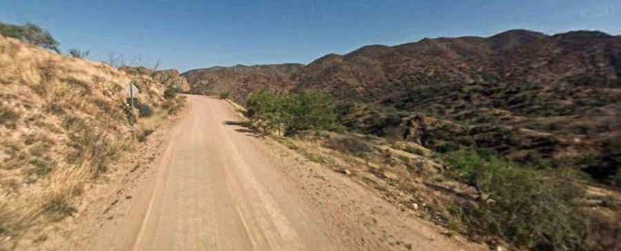
Is Ruby Road paved?
Ruby Road #289/39 Scenic Drive includes paved and unpaved sections with a few water crossings. It is paved for its first 12 miles to Peña Blanca Lake (created by a dam in 1957). From that point, it is a graded dirt road suitable for high-clearance vehicle for the next 25 miles to the town of Arivaca. The road conditions vary, but there are several rough patches, which means a high-clearance vehicle is a must.
How challenging is Ruby Road?
The road tops out at 1,472 m (4,829 ft) above sea level. The narrow road lacks guardrails and includes several sheer drop-offs. Slow speeds are recommended on this winding road. Also, note that unpaved portions of Ruby Road can be slippery and rutted when wet. Don’t travel alone, and let someone know where you are going and when you plan to return. The drive is pretty demanding because you’re concentrating on avoiding potholes and may inadvertently drift into the opposite side of the road while doing so, neglecting to pay attention to traffic.
How long does it take to drive Ruby Road?
This is a remarkable road trip in an area of rugged mountains, semi-arid deserts, and abundant wildlife. Remember to bring your camera. Plan 2-3 hours of driving time without any stops. Along the way, the road offers stunning views of rolling hills and towering buttes, a desert oasis inhabited by rare plants and birds, two picturesque lakes, and Ruby, an old ghost town. This is a good area to explore if you like ghost towns. On the road to Arivaca, you'll pass what's left of Ruby, Oro Blanco, and several abandoned mining camps. Arivaca itself is billed as a ghost town even though people still live there. Ruby, the ghost town, was reportedly named after a pioneer resident who lived in the town when it opened its first U.S. Post Office.
When is the best time to drive Ruby Road?
Located 8 miles north of the Mexican border, in the southern part of Arizona, the best times to visit this area are late fall, winter, and early spring. Temperatures can exceed 100 degrees anytime from April through October. Many of the interesting desert plants are succulent perennials that can be observed during any season. If you make a summer visit, try getting out in the early morning before the intense heat of the day. Desert heat and low humidity are real hazards for people unfamiliar with hot climates. A person can lose up to 5 quarts of fluid a day, and it is easy to become seriously dehydrated without realizing it, so drink plenty of fluids even if you do not feel very thirsty. Always carry extra water in your car. When going on a hike, even if it's a short one, take a day pack with water, snack foods, protective clothing, flashlight, first aid kit, compass, and map. To avoid sun injury, wear light loose clothing, use sunscreen on exposed areas, wear a hat, and have good sunglasses. Be especially careful with snakes. There are plenty of rattlesnakes.