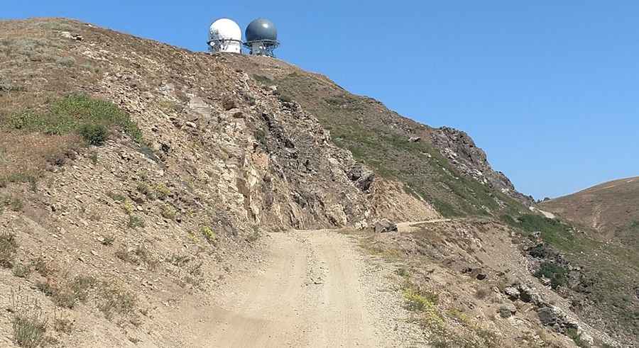
A narrow dirt road with steep drop offs to Francis Peak in Utah
Francis Peak is a high mountain peak at an elevation of 2.887m (9,471ft) above sea level, located in the U.S. state of Utah. Most cars can make this bumpy journey, though it is a back-country road.
Where is Francis Peak?
The peak is located on the boundary between Davis and Morgan counties, in the northern part of Utah.
Why is it called Francis Peak?
The peak is named after Ester Francis, an early Mormon pioneer who settled in Morgan during the 1800s.
Can you drive to Francis Peak?
Set high in the Wasatch Range, the road to the summit is mostly unpaved. It is paved for the first mile until the first switchback in the canyon and then follows a winding, narrow dirt road for another 12 miles. It’s called Francis Peak Road (also known as Skyline Drive or Farmington Canyon Road).
How long is the road to Francis Peak?
The road to the summit is very steep. Starting from Farmington, the ascent is 20.59km (12.79 miles) long. The elevation gain is 1.561 meters and the average gradient is 7.58%.
Is the road to Francis Peak challenging?
It’s a narrow winding dirt road with steep drop-offs. Cell phone coverage is iffy all along the ridge.
Is the road to Francis Peak in UT open?
The road is no longer plowed in winters. Snowfields usually block some portion or all of the longer routes well into June.
What is on top of Francis Peak?
Located within the Wasatch-Cache National Forest, the summit hosts two radar towers constructed in 1959. The top is a restricted zone closed by a barrier. Access by permit only. You cannot actually come to the very top as there are critical radar towers for airplanes that block you from entering. The domes, operated by the Federation Aviation Administration and the Air National Guard, provide long-range radar and identification for area aircraft. The top ridge is a haven for rattlesnakes which tend to sun themselves near the rock formations. The view from the top is spectacular in all directions with a great view of Morgan (east) and the Great Salt Lake (west).
Pic: Chuck Tracy