How to get to Cerro Gordo, California's Silver Mining Ghost Town, by car?
Cerro Gordo (Spanish for "Fat Hill") is a silver mining ghost town located in Inyo County, in the U.S. state of California.
Where is Cerro Gordo?
The ghost town is located in the eastern-central part of California, within the Inyo National Forest.
When was the road to Cerro Gordo built?
The first road to the town was a wagon road constructed in July 1868.
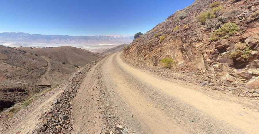
How long is the road to Cerro Gordo?
Set high in the rugged western slope of the Inyo Mountains, east of Owens Lake, the road to the town is called Cerro Gordo Road. It is 20.27km (12.6 miles) long, running west to east from California State Route 136, near Keeler to White Mountain Talc Road. It climbs rapidly through a corridor through the Inyo Mountains Wilderness and runs along the ridge atop the Inyo Mountains. You can use a two-wheel drive until you get to the Cerro Gordo town site. High-clearance 4x4 is needed for the road east, which is washed out and very rocky. In either direction, there are very steep ascents which necessitate low range gears. This route is very remote. The narrow, winding gravel road is prone to washouts and rock slides.
Is Cerro Gordo Road worth it?
It’s a great drive with terrific views to see the living history of Cerro Gordo, a semi-ghost town with a long and often wild history. The drive offers terrific views, wildflowers, and historical mining structures. During this trip, everyone took tons of photos. Take special care with rattlesnakes.
Is the road to Cerro Gordo open?
Located near Lone Pine, the road tops out at 2.502m (8,208ft) above sea level. Due to the high elevation, the trail may be closed due to snow. Make sure to check road conditions and do not drive if you think this is unsafe. The road will likely be snow-covered between November and April. Chains may be required.
When is the best time to get to Cerro Gordo?
The best time to visit is late spring, summer (can be extremely hot) and autumn. Cerro Gordo is open all week (depending on road/weather conditions) from 9 a.m to 4 p.m standard time and 9 a.m to 5 p.m daylight savings time.
Driving to the FAA site near Gordo town
To the north of the town, a short 4x4 road climbs up to an FAA site, at 2.811m (9,222ft) above sea level. It's 2.89km (1.8 miles) long. It’s one of the highest roads of California.
Pic: James Hatton