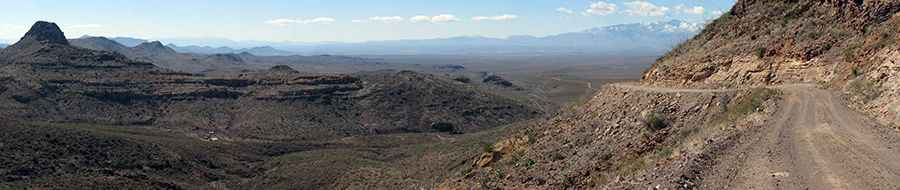
Driving the historic Black Hills Scenic Byway in Arizona
Black Hills Scenic Byway is a scenic unpaved road located along Greenlee and Graham counties, in the U.S. state of Arizona.
Where is the Black Hills Scenic Byway?
The road is located between Safford and Clifton, in the southeastern part of Arizona.
When was the Black Hills Scenic Byway built?
The road was built by prison laborers between 1914 and 1920. It’s also known as Black Hills Back Country Byway.
How long is the Black Hills Scenic Byway?
The road is 33.95 km (21.1 miles) long, running northeast to southwest. Both ends of the byway are accessed from U.S. Highway 191.
Can I drive my vehicle on the Black Hills Scenic Byway?
It’s a very scenic byway winding through the forest for high-clearance vehicles during dry weather. If it's wet, sometimes no amount of 4WD helps. A four-wheel-drive vehicle is necessary if you plan to explore one of the numerous side roads along the way. Do not attempt the byway if you have a travel trailer or any vehicle more than 20 feet long. Motor homes and trailers can be left at parking areas provided near kiosks at each end.
Is the Black Hills Scenic Byway unpaved?
The road is totally unpaved.
How long does it take to drive the Black Hills Scenic Byway?
There usually isn't much traffic. Plan 45 minutes without any stop. The road, through desert emptiness, is filled with wonderful destinations for visitors to explore.
Is the Black Hills Scenic Byway dangerous?
Running through the northern end of the Peloncillo Mountains, the road features steep sections and tops out at 1,688m (5,538ft) above sea level. The weather in this zone is harsh and highly unpredictable. Arizona weather can change quickly. Be prepared. Dress in layers, wear a hat, and pack sunscreen. Always carry plenty of water. Please take extra care to drive defensively on this route. Portions of the byway have narrow drop-offs or are confined by steep cliffs. Always expect a vehicle around the next bend, and remember: mountain courtesy gives uphill traffic the right of way. Sections of the route are curvy and winding, and drop-offs on one side with cliffs on the other are the norm.
Pic: https://www.rvecafe.com/nmex04.html