Cottonwood Pass is a beautiful scenic drive in Colorado
Cottonwood Pass is a high mountain pass at an elevation of 3,696m (12,126ft) above sea level, located in the U.S. state of Colorado. The road to the summit provides a beautiful scenic drive and is one of the highest roads in Colorado.
Where is Cottonwood Pass?
The pass is located on the boundary between Chaffee and Gunnison counties, in the central part of Colorado.
When was the road through Cottonwood Pass built?
The idea for the road began in 1955 when the Forest Service needed a way to get timber out. By 1958, there was a road – but it was dirt.
How long is the road to Cottonwood Pass?
The pass road is 51.01 km (31.7 miles) long, running east-west from the Town of Buena Vista to County Road 742, near Taylor Park Reservoir. It’s a great shortcut between Buena Vista and Crested Butte and is a great alternative to Monarch Pass a few miles to the south. The road to the summit, running from Buena Vista to the east, is called Chaffee County Road 306, but near the summit, it changes to Gunnison County Road 209 as it continues to the west.
Is Cottonwood Pass paved all the way?
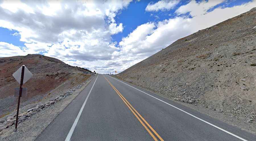
After long-term closures (3 years) and heavy construction, the road to the summit was fully paved the entire way from Buena Vista to Taylor Park Reservoir (and to Crested Butte and/or Gunnison) in 2019. The newly paved west side is wide and smooth, with no problem for any type of vehicle. Additional improvements to come include two 11-foot travel lanes with shoulders, guardrails, protection from rockfall, and additional parking areas at the summit and Denny Creek.
How difficult is Cottonwood Pass?
The road has switchbacks, scenery, and very little traffic. Near the top, there are several switchbacks that are so tight that the speed limit is 15 mph (25kph). The road is steep in parts, hitting a 10% maximum gradient through some of the ramps, making it a pretty challenging drive for drivers towing trailers (RVs) and driving large motorhomes.
Is Cottonwood Pass Colorado Open?
Set high in the Rocky Mountains, the pass tops out over 12,100 feet (the third-highest paved road in the state). Note that there are seasonal gates at both ends, and the road is closed seasonally due to heavy snowfall, typically from around October until sometime in May. When open, the pass is one of the few routes through the Sawatch Range accessible in a standard two-wheel-drive passenger vehicle. Thunderstorms often develop in the afternoon in the Colorado high country. Visiting early and being back by your vehicle early in the day is advisable. Be aware of high altitude sickness, which can be life-threatening. Hypothermia can be a hazard throughout the year. Given that the pass is over 12,000, it’s likely you will find snow at the summit year-round. But more than that, this is a pass where the weather will change rapidly, and any attempt to ride the pass should be done with due care. The ride is rather remote, and you won’t see too many other people if you need help. In July 2002, heavy rains from a thunderstorm east of Cottonwood Pass caused a significant mudslide that blocked portions of the road for many days.
How long does it take to drive the Cottonwood Pass road?
The drive is famous for beautiful scenic views along the way, and it’s an excellent drive for 2WD cars. Plan 1 hour to complete the drive without any stop. The drive is a great one to take in the fall to enjoy the changing colors before the snow comes. There is a nice parking area at the top with expansive views to both the east and west sides of the Continental Divide. It is well worth the trip. There are a few overlooks on the way down from the pass that are definitely worth the stop.