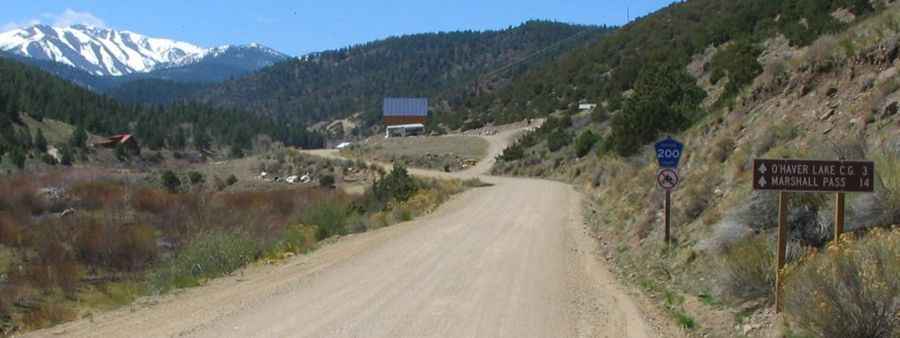
The unpaved mountain road to Marshall Pass in Colorado
Marshall Pass is a high mountain pass at an elevation of 3.305m (10,842ft) above sea level, located in Saguache County, in the U.S. state of Colorado.
Where is Marshall Pass?
The pass is located just a few miles south of Monarch Pass, in the northern part of Saguache County, in central-southern Colorado. It was discovered by and named for Lt. William L. Marshall, of the Wheeler Survey, in 1873.
When was the road to Marshall Pass in Colorado built?
Much of the road to the summit follows a former railroad grade for the Denver & Rio Grande en route to Salt Lake City over 100 years ago, so it never climbs steeply and to gain elevation, it seemingly winds all around to gain the pass. The Marshall Pass Toll Road was completed in 1878.
Is Marshall Pass unpaved?
The road to the summit is totally unpaved. It’s called Marshall Pass Road.
Can I drive my vehicle through Marshall Pass?
It may be driven by regular passenger cars in good conditions. For the most part, it isn't too bad. There are a few rough spots, but a 2WD passenger vehicle can make it just fine if you take your time. For very low clearance vehicles, there are a few humps on the road, particularly on the west side, that you’d need to be careful about.
Is Marshall Pass open?
Set high in the Rocky Mountains, the road is not plowed in winters and closed to wheeled vehicles during the coldest months.
Is Marshall Pass worth it?
The drive offers amazing views of the Sangre de Cristo Mountain range. In the summer and late fall, this drive is especially beautiful. On both sides of Marshall Pass, and especially in the vicinity of the pass, you can find at-large, primitive campsites.
How long is Marshall Pass?
The pass is 48.92km (30.4 miles) long, running from Sargents (US-50) to Mears Junction (Highway 285).
More info &pics: http://ponchasprings.org/marshall-pass-road.htm