Cumberland Pass in Colorado is the highest standard passenger vehicle road in the USA
Cumberland Pass is a mountain pass at an elevation of 3,670m (12,040ft) above sea level, located in Gunnison County, in the U.S. state of Colorado. It's said to be one of the highest standard car roads for summer use in the nation. It's one of the highest roads in Colorado.
Where is Cumberland Pass?
The pass is located in the central part of Colorado, within the Gunnison National Forest.
When was the road through Cumberland Pass built?
The first road through the summit was constructed in 1882 to connect Tincup with the Denver-South Park railroad in Pitkin. The road was later improved by the Civilian Conservation Corps in 1935 and improved again in the 1950s.
How long is the road to Cumberland Pass?
The road to the summit is called County Road 765 (Cumberland Pass Road). The drive is 25.42km (15.8 miles) long, running north-south from Tincup (or Tin Cup) to Pitkin.
Is the road to Cumberland Pass in Colorado dangerous?
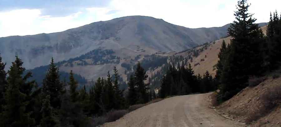
This road is graded and quite easy. The windy road with many tight turns to the summit is totally unpaved but generally in good condition, although it can get bumpy in places. It can be sandy and resemble a washboard. It’s generally kept in very good condition and can be accessed by most passenger vehicles without any problems (suitable for either 4WD or 2WD vehicles). The road is never too steep. There are a few narrow spots, and the sides have steep drop-offs. Take your time, and you will have very few difficulties.
Is the road to Cumberland Pass in Colorado open?
Set high in the Sawatch Range of the Rocky Mountains of Colorado, the pass receives a heavy amount of snowfall in the winter, and the road is usually impassable from late October through late June or early July.
Is the road to Cumberland Pass worth it?
It’s said to be one of Colorado's most scenic and historic passes. This is a remarkable road trip. Eventually, the road moves above the tree line, and the view is stunning. From the summit, you can view over 50 miles of the Continental Divide. From Tin Cup, the pass climbs through beautiful pine forests, clinging to the side of mountains. Along the road, you will pass a number of mine entrances along the way. Please stay out of them. There are also a number of access roads that head off into the various Silver mines on this mountain.
Pic&Video: Walter Baumgarten