Going-to-the-Sun Road is a scenic marvel of Glacier National Park of Montana
Going-to-the-Sun Road is one of the most amazing highlights of Glacier National Park in the U.S. state of Montana. This engineering marvel is considered one of the most scenic drives in the world and is among the most difficult roads in North America to snowplow in the spring.
How long is the Going-to-the-Sun Road?
Set high in the Rocky Mountains of the western United States, the road is 80.46 km (50.0 miles) long, running from West Glacier (in eastern Flathead County) to St. Mary (in Glacier County). It's recognized as one of America’s 15 Best Motorcycling Roads.
Is the Going-to-the-Sun Road paved?
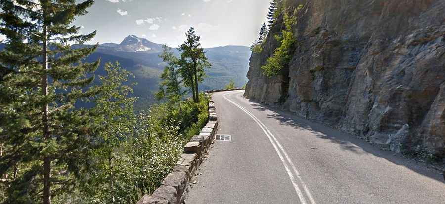
The road, nicknamed the crown jewel of scenic drives in Montana, is entirely paved but quite narrow. It’s a winding two-lane highway with hairpin turns bisecting Glacier National Park from west to east. While it offers spectacular views, the road is also dangerous, featuring twisting turns and ridiculously narrow lanes. Vehicles, and combinations wider than 8ft (including mirrors), are prohibited between Avalanche Campground and the Rising Sun picnic area parking. Vehicles over 10 feet in height may face difficulty driving west from Logan Pass to the Loop, due to rock overhangs. Stock trucks and trailers can access Packers Roost on the west and Siyeh Bend on the east. Portions of the road hug the mountainside, traversing steep drop-offs and winding through tight curves.
When was the Going-to-the-Sun Road built?
This engineering marvel is hailed as one of the most scenic drives in the USA. Construction began in 1921, completed in 1932, and opened to the public in July 1933. In 1938, portions of the road were paved with asphalt. It’s the only road that crosses Glacier National Park. In 1983, the road was included in the National Register of Historic Places, and in 1985, it was designated a National Historic Civil Engineering Landmark.
How long does it take to drive the Going-to-the-Sun Road?
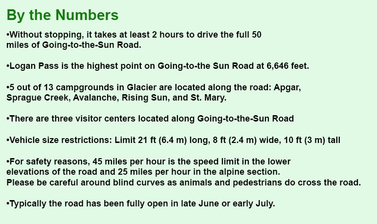
Without stopping, it takes at least 2 hours to drive the full road. The road carries travelers through some of the most spectacular scenery the park has to offer. It’s one of the most picturesque, photogenic, breathtakingly beautiful drives in Montana. This engineering marvel runs through the park's wild interior, winding around mountainsides and treating visitors to some of the best sights in northwest Montana. The drive passes through almost every type of terrain in the park, from large glacial lakes and cedar forests in the lower valleys to windswept alpine tundra atop the pass. Scenic viewpoints and pullouts line the road, allowing motorists to stop for extended views and photo opportunities. It passes through almost every type of terrain in the park, from windswept alpine tundra atop the pass to large glacial lakes and cedar forests in the lower valleys. It’s well worth traveling in either direction, as the view from one side of the road is much different than from the other.
Is the Going-to-the-Sun Road open?
The road is usually open from mid-June through mid-October but can change due to weather conditions at any point. Up to 80 feet (24 m) of snow can lie on top of Logan Pass, and more just east of the pass, where the deepest snowfield has long been referred to as Big Drift. It’s said to be one of the most difficult roads in North America to snowplow in the spring. Portions of Going-to-the-Sun Road remain open all year, providing access to many locations and activities.
Why is it called Going to the Sun Road?
The road is named after nearby Going-to-the-Sun Mountain.
What’s the highest point of Going-to-the-Sun Road?
The road tops out at Logan Pass, at 2,026m (6,646ft) above sea level.
🔔 CRITICAL ACCESS UPDATE
Due to extremely high visitor numbers (Glacier National Park), driving the Going-to-the-Sun Road is now restricted during peak summer months (typically late May through early September).
WHAT YOU MUST KNOW:
- Mandatory Reservation System: It is required to obtain a Timed Entry Vehicle Reservation Permit before your visit.
- How it Works: Reservations must be secured in advance through the National Park Service (NPS) system. They often utilize a lottery-style system due to extremely high demand.
- Denied Access: Without a valid reservation permit, you will be denied access to the road during restricted hours.
- Recommendation: Always check the official Glacier National Park website for the specific dates, times, and rules for the current year before planning your trip.
Road suggested by: JR Montana