Dare to drive the challenging Camp Bird Road -County Road 361- in Colorado
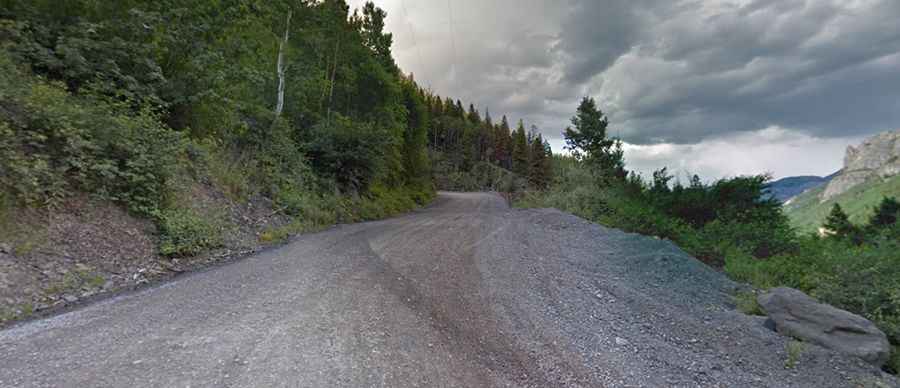
Camp Bird Road is a picturesque mountain road with narrow shelf sections located southwest of Ouray County, in the U.S. state of Colorado. A 4WD vehicle and no fear of heights are recommended.
How long is Camp Bird Road?
The road, also known as County Road 361, is totally unpaved with a compact dirt surface. It’s 8.20 km (5.1 miles) long, running east-southwest from Ouray (on Million Dollar Highway) to Camp Bird. Ouray is a town originally established by miners chasing silver and gold in the surrounding mountains, and Camp Bird is a famous and highly productive old gold mine located between Ouray and Telluride. It has been around since the mid-1800s and has produced well over a million troy ounces of gold. The mine is within the Sneffels-Red Mountain-Telluride mining district.
Is Camp Bird Road in Colorado open now?
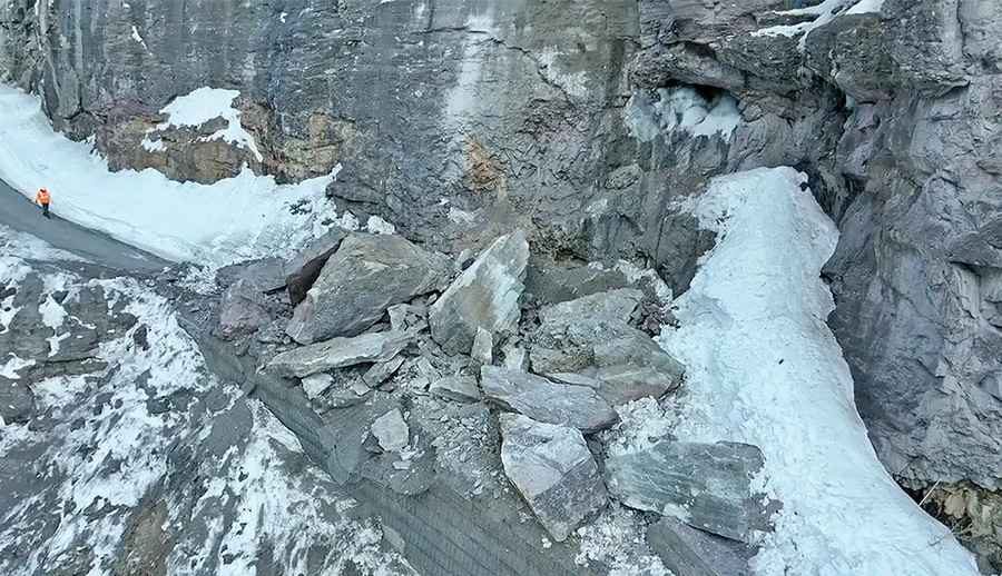
As of May 2025, Camp Bird Road (County Road 361) remains indefinitely closed due to a significant rockslide that occurred in late February. Several large boulders fell onto the road, damaging a section near the Hilfiker wall, which also suffered further damage during initial mitigation efforts.
The closure begins 3.5 miles from U.S. Highway 550, about 200 yards beyond the Senator Gulch gate. There is no public access beyond this point, and the Ouray County Sheriff’s Office is enforcing the closure. Buckhorn Engineering, after reviewing drone footage, deemed the site life-threatening due to unstable overhanging rock and the potential for additional rockfalls caused by fluctuating temperatures.
Repair efforts are ongoing, with engineering assessments and reconstruction proposals under review. Officials estimate the situation will take at least six weeks to address, but no official reopening date has been set. The road crosses both county and U.S. Forest Service land, as well as private property, and coordination among agencies is ongoing.
Pic: Ouray County
Camp Bird Road is one of the county’s most heavily used backcountry routes in summer, although less accessible in winter. It remains closed until all safety and repair measures are complete. For more information, contact the Ouray County Road & Bridge Department at 970-626-5391.
Is Camp Bird Road open in winters?
Located above Ouray in the San Juan Mountains, the first part of the road (the first 4 miles—to the Senator Creek area) is open year-round. The rest, marked by a winter gate, is only open during the summer months. The road provides access to Yankee Boy Basin and Imogene Pass and then down to Telluride. The road is exposed and can get very icy. There is an avalanche danger on the road.
When was Camp Bird Road in Colorado built?
Tucked away in the Uncompahgre National Forest, the road was built by Otto Mears as a toll road to service the mines and was finished in 1883. The road is named after a mining company called Camp Bird.
Is Camp Bird Road dangerous?
The narrow, picturesque mountain road is not easy. Avoid it if you have a fear of heights. This road becomes more and more "interesting" with each passing mile—turning from a graded dirt road into a slightly bumpy shelf road, finally ending up as a moderate 4WD road with some steep, rough, rutted sections that shouldn't be attempted by any low-clearance 2WD vehicles at all. The road gets rougher higher up. As you climb up Camp Bird Road, the trail gets a little steeper, but it's still not a difficult drive. The road is narrow at the higher sections, and passing other vehicles is nearly impossible, so be prepared that you can get stuck in traffic on summer weekends.
Do I need a 4WD vehicle to drive Camp Bird Road in Colorado?
High-clearance 4WDs are preferred, but any high-clearance vehicle is acceptable in good weather. Expect a rough road surface; mud and sand are possible but will be easily passable.
Is Camp Bird Road in Colorado steep?
It's a high mountain road, ending at 3,000m (9,842ft) above sea level. The road is very steep, with a 16% maximum gradient through some of the ramps. Starting at Ouray, the drive is 8.20 km (5.1 miles) long. Over this distance, the elevation gain is 592 meters. The average gradient is 7.21%.
With over 13,000 roads cataloged, we're always on the lookout for unique routes. Know of a road that deserves to be featured? Click here to share your suggestion, and we may add it to dangerousroads.org.