Driving the Forest Service Road 310 to Blue Nose
Blue Nose is a high mountain peak at an elevation of 2,641m (8,664ft) above sea level located on the border between Montana and Idaho.
| Road facts: Blue Nose | |
|---|---|
| Location | Montana-Idaho border (Salmon National Forest) |
| Max Elevation | 2,641m (8,664ft) |
| Length | 1.2 miles (1.93 km) |
| Average Gradient | 7.77% |
Why is there a road to Blue Nose?
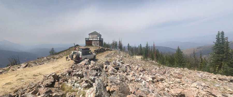
Set high in the Salmon National Forest, the summit hosts a historic fire lookout tower built in 1934.
Is the road to Blue Nose unpaved?
The road to the summit is totally unpaved. It’s called Forest Service Road 310. The road is notoriously rocky, bumpy, and "tippy" in several sections where the track narrows significantly.
How long is the road to Blue Nose?
Starting at the junction with the NF-044 road, the road to the summit is 1.2 miles long. Over this distance, the elevation gain is 492 feet and the average gradient is 7.77%. High-clearance 4x4 vehicle required.
Is the road to Blue Nose open year-round?
The road to Blue Nose is subject to the weather of the Montana-Idaho border. During wet periods, the clay-heavy soil of the Salmon National Forest turns into a thick, slippery mud. At an elevation of 8,664ft, Blue Nose is buried under heavy snow for most of the year, making the road impassable from late autumn through early summer. Even in the height of the driving season, sudden storms can drop temperatures to freezing levels and wash debris onto the track.
Pic: Wes Craiglow