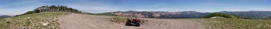
How to drive the unpaved road to High Mountain in Utah?
High Mountain is a high mountain peak at an elevation of 3,030m (9,940ft) above sea level, located in Iron County, in the US state of Utah.
| Road facts: High Mountain (NF-281) | |
|---|---|
| Location | Iron County, Utah (USA) |
| Elevation | 3,030 m (9,940 ft) |
| Length | 1.6 km (1.0 mile) |
| Surface | Loose Rock and Deep Ruts |
Where is High Mountain?
The peak is located south of Parowan, in the southwestern part of Utah, within the Dixie National Forest.
Is the Forest Service Road 281 to the High Mountain Summit unpaved?
The road to the summit is totally unpaved. It’s called Forest Service Road 281 (NF-281). It consists of loose volcanic rock and dirt. The track is narrow and tippy in several sections. If you encounter another vehicle, someone will have to reverse on a narrow, rocky ledge. High-clearance vehicle required.
How long is the Forest Service Road 281 to the High Mountain Summit?
Starting from FR 265, the road to the summit is 1.6 km (1.0 mile) long. Over this distance, the elevation gain is 84 meters with an average gradient of 5.25%.
Is the Forest Service Road 281 to the High Mountain Summit open year-round?
The road is buried under heavy snow from October until at least late June or July. It is never plowed. The best window to reach the summit is from mid-July to September.
Pic: Dave Stillman