Magruder Road Corridor: The Ultimate Test of Remote Off-Road Navigation
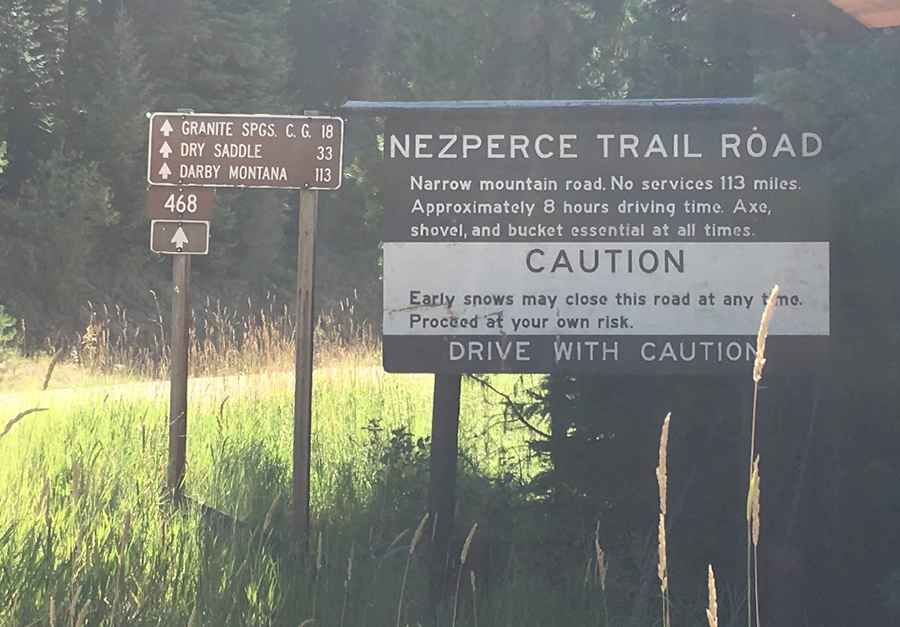
The Magruder Road Corridor, officially Forest Service Road 468, stretching between Elk City, Idaho, and Darby, Montana, is one of the most remote and primitive tracks in the lower 48 states. Carving a thin line between two massive wilderness areas—the Selway-Bitterroot and the Frank Church-River of No Return—this 101-mile (162 km) forest road offers no services, no cell signal, and no room for mechanical error. It is a high-altitude transit through the heart of the Bitterroot Mountains, where the environment remains as rugged and unforgiving as it was a century ago.
| Road facts: Magruder Road Corridor (FS 468) | |
|---|---|
| Location | Elk City (ID) to Darby (MT) |
| Length | 101 miles (162 km) |
| Avg. Speed | 12-15 mph (19-24 km/h) |
| Hazard Level | High (Isolation, narrow shelf roads, extreme weather) |
Is the Magruder Road Corridor suitable for standard vehicles?
This is not an excursion for standard passenger cars or low-clearance vehicles. The Magruder Road Corridor is a single-lane, primitive forest track that features steep gradients and narrow shelf sections with no guardrails. Passing oncoming traffic requires precise maneuvering and reversing to designated turnouts. High-clearance 4WD vehicles are essential, as the road surface is unpaved, rocky, and subject to significant erosion and washouts.
What are the primary hazards of the Magruder Road Corridor?
The greatest danger of the Magruder Road Corridor is its absolute isolation. There are no services—no fuel, food, or water—for the entire 101-mile stretch. Additionally, extreme weather can turn the route treacherous in minutes; sudden summer thunderstorms create slick mud, while early autumn snowfalls can block high passes like Dry Saddle, trapping unprepared travelers in a zone with zero cellular coverage. Mechanical self-sufficiency is mandatory.
How long does it take to drive the Magruder Road Corridor?
Due to the primitive nature of the terrain, the average speed on the Magruder Road Corridor is approximately 12 to 15 mph. A full transit typically requires two full days of focused driving. Strategic fuel planning is mandatory; low-gear crawling and constant elevation gains significantly increase consumption compared to standard highway driving. Always start the journey with a full tank from either Elk City or Darby.
Where are the best campsites along the Magruder Road Corridor?
For those planning a multi-day transit, several primitive campsites managed by the USFS provide strategic stopovers. These locations offer no amenities but are essential for managing driver fatigue:
- Granite Springs Campground: Located on the western side, ideal for the first night.
- Magruder Crossing: A scenic spot where the road meets the Selway River.
- Burnt Knob Lookout Area: Offers high-altitude dispersed camping with 360-degree vistas.
- Deep Creek Campground: Situated near the eastern exit toward Montana.
What are the essential GPS waypoints for the Magruder Road Corridor?
Navigation in a zone with zero connectivity requires pre-loaded coordinates and physical maps. Key technical points for your GPS include:
- Western Entrance (Red River): 45.71030, -115.34409
- Dry Saddle Pass: 45.67741, -114.99289 (Critical high-altitude landmark)
- Burnt Knob Lookout: 45.70162, -114.99025 (Elevation 8,011 ft)
- Nez Perce Pass (ID/MT Border): 45.7107, -114.2800
What is the connection between Magruder Road and the Nez Perce Trail?
The modern Magruder Road Corridor follows the ancestral path of the **Southern Nez Perce Trail** (or Nez Perce Trail Road). For centuries, the Nimiipuu people used this rugged mountain crossing to travel between the salmon-rich rivers of Idaho and the buffalo hunting grounds of Montana. Evidence of this heritage can be seen at various historical markers along the route. Driving this road is as much a historical expedition as it is an off-road challenge.
Conclusion: Preparing for the Magruder Road Experience
The Magruder Road Corridor is a rewarding journey for those who respect the limits of their vehicle and the power of the wilderness. It is a rare opportunity to experience the American West in its rawest form. Before departure, verify fire and weather reports with the Forest Service, ensure your recovery gear is complete, and inform a third party of your expected exit time. In this corridor, your preparation is your only safety net.
Pic: Sir Mashington