4 Reasons to Take a Trip Along the Coast of California
California, the most populous state in the US with 38 million residents, features over 840 miles of diverse coastline along the Pacific Ocean. Navigating this vast territory requires a strategic approach to diverse road systems, from high-density urban interchanges to technical mountain passes. For the professional traveler, the California coast is not just a scenic destination but a complex environment where vehicle dynamics and topographical awareness are essential for a safe and efficient transit.
| California Coastal Routes: Technical Summary | |
|---|---|
| Primary Artery | Pacific Coast Highway (PCH) - 656 miles |
| Technical Pass | Patchen Pass (Steep gradients and blind curves) |
| Urban Density | Los Angeles Metro & San Francisco Bay Area |
| Environmental Risk | Rockslides, coastal fog, and seismic volatility |
What makes the Pacific Coast Highway a milestone for long-distance drivers?
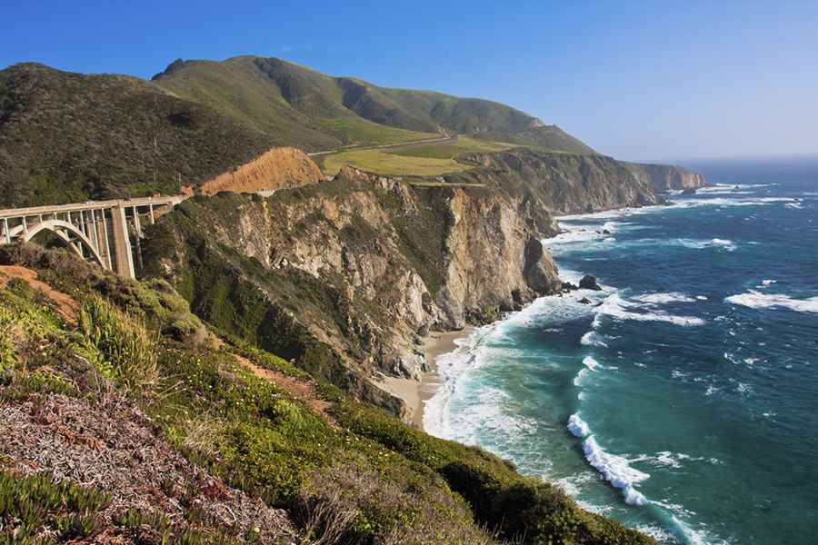
The Pacific Coast Highway (PCH) is the longest state road in California, stretching 656 miles. While it is globally renowned for its scenic value, it presents significant logistical challenges for motorists. The route is prone to coastal erosion and periodic landslides, particularly in the Big Sur segment. Navigating the PCH requires constant monitoring of Caltrans alerts and an awareness of the narrow shoulder widths that define many of its historic cliffside sections.
Are the canyon roads in Malibu technically challenging?
For those seeking a more rigorous driving experience, the Santa Monica Mountains offer some of the most technical asphalt in the state. If you are analyzing the most dangerous and technical canyon roads in Malibu, you will find a network of tight-radius curves and steep grades. Similarly, Patchen Pass between San Jose and Santa Cruz demands extreme precision due to its narrow lanes and numerous blind spots. These mountain roadways require high-performance braking systems and advanced situational awareness to manage the frequent rockslides and sudden atmospheric changes.
How does urban density affect logistics in Los Angeles and San Francisco?
Navigating the sprawling metropolitan areas of the California coast requires a tactical approach to high-volume traffic. Los Angeles, the second-largest city in the country, operates as a massive "creative capital," but its infrastructure is often at its limit. To the north, the San Francisco Bay Area—including San Jose—features unique landmarks like the Golden Gate Bridge and the Winchester Mystery House. For the professional driver, these centers represent the intersection of extreme urban congestion and complex bridge logistics, where route timing is critical for avoiding hours of idling.
What environmental wonders define Northern California’s infrastructure?
The northern segment of the coast is home to the Redwood National and State Parks, where the infrastructure must accommodate the protection of the world's tallest trees, such as the 116-meter Hyperion. Further south, in San Simeon, the Piedras Blancas Rookery hosts thousands of elephant seals. Driving through these protected zones requires adherence to specific wildlife crossing protocols and an awareness of how the massive redwood root systems and coastal humidity can impact road surface integrity over time.
What are the logistical risks of coastal adventurous activities?
Engaging in activities such as scuba diving or paddleboarding along the Pacific requires a logistical base. For the overlander, this means managing equipment weight and vehicle storage in coastal salt-air environments that accelerate corrosion. Whether navigating the wine country stretches of Highway 101 or scouting remote beach access points for surfing, maintaining a vehicle’s mechanical readiness is essential for ensuring that an adventurous spirit is matched by professional-grade safety standards.
Conclusion: The Professional Standard of California Coastal Travel
California is a state of extremes, where jaw-dropping nature meets some of the most complex infrastructure in the world. By prioritizing technical route planning—from the canyons of Malibu to the foggy cliffs of the PCH—and respecting the environmental limits of the Pacific seaboard, drivers can safely experience the diversity of the Golden State. On the California coast, the most successful journey is one that is planned with the same precision as a professional expedition.
Image credit: Depositphotos