Driving the rugged forest road to Indian Ridge Lookout
Indian Ridge is a high-altitude summit standing at 1,647 meters above sea level in Lane County, Oregon. Tucked deep within the Willamette National Forest, the final push to the top is a raw forest track that leads to a historic 1958 fire lookout tower. This isn't a scenic drive for city cars; it’s a journey through the Cascade Range where the road surface is a mix of jagged rock and shifting gravel. While it’s technically navigable, the reality is a bumpy, high-vibration climb that will test your vehicle's underbody and your patience as you crawl toward one of the best vantage points for fire surveillance in the region.
| Road facts: Indian Ridge (FSR 1980) | |
|---|---|
| Location | Lane County, Oregon, USA |
| Elevation | 1,647m (5,403ft) |
| Distance | 3.70 km (2.3 miles) |
| Surface | Unpaved / Rock & Gravel |
Where is Indian Ridge located?
The peak is located in the west-central part of Oregon, anchored in the rugged Cascades of the Willamette National Forest. To get there, you have to leave the main valley roads and commit to the forest service network, specifically the NF-2618. This is a remote geographical point where the forest is dense and the isolation is real. You are miles away from the nearest town, and once you start the final climb, the terrain becomes a labyrinth of timber and rock where navigation depends on following the FSR 1980-247 track precisely.
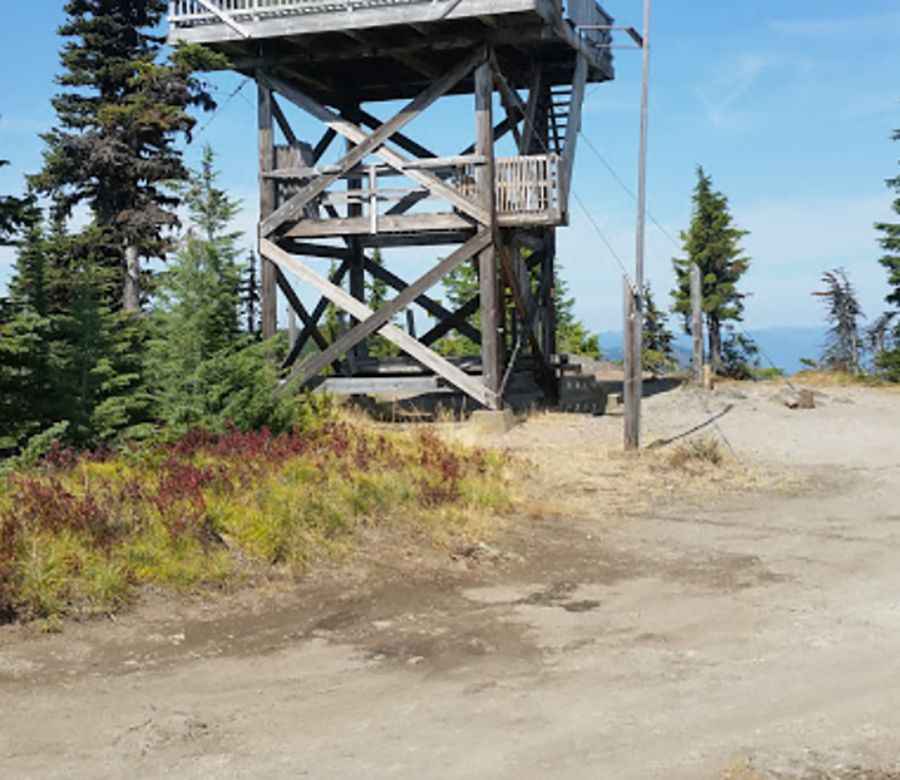
What’s at the summit of Indian Ridge?
The summit is dominated by the Indian Ridge Lookout Tower, a structural relic from 1958. While it’s a piece of history, for a driver, the summit is a high-altitude dead-end with limited space to turn around. The tower is still staffed during emergency fire seasons, meaning you might encounter forest service furgonetas or official vehicles on the narrow path. The view of the Cascade peaks is vast, but the real focus here is the tower itself, which sits exposed to the high-altitude winds and lightning that characterize this part of Oregon.
Is the road to Indian Ridge unpaved?
Yes, the road to the summit (FSR 1980-247) is entirely unpaved and consistently rough. The surface is a punishing combination of embedded rocks and loose gravel that has been weathered by years of snowmelt. This is a "slow-speed" track; if you try to hurry, you risk shredding a tire or cracking a sump on a stray rock. The vibration is constant, and the dust during the dry summer months can be so thick that it clogs air filters and obscures the deep ruts that line the path. It is a primitive road that demands respect for the mechanical limits of your car.
Can I drive my vehicle to Indian Ridge?
While you don't strictly need a 4x4, taking a low-clearance passenger car is a gamble. The road is "navigable," but every centimeter of clearance counts when you hit the deeper ruts or the rocky outcrops of the FSR 1980. If you are driving a standard car, you will be crawling at walking pace to avoid expensive underbody damage. A high-clearance vehicle is a massive advantage here, allowing you to straddle the ruts rather than being forced into them. If the ground is wet, the loose gravel turns into a slippery mess where even a small incline can become a challenge for two-wheel-drive vehicles.
How long is the road to Indian Ridge?
The final approach from the junction with NF-2618 is only 2.3 miles (3.70 km), but don't let the short distance fool you. Because of the rocky surface and the narrow ledge-like sections, this climb will take much longer than a standard drive. You will spend the entire distance in low gears, managing your torque to navigate the uneven ground. It is a short, concentrated burst of technical forest driving where the elevation gain is felt in every gear change and every bump in the suspension.
Is the road to Indian Ridge open in winter?
Absolutely not. The road is impassable from late October through June or even early July. This part of the Cascades receives heavy snowfall that completely buries the FSR 1980. Even when the snow starts to melt, the road becomes a muddy trap that can swallow tires. Access is entirely dependent on the annual snowpack, and trying to push through early in the season is a guaranteed way to get stranded. In summer, the heat can hit 80°F, putting stress on your cooling system during the slow climb, while the 30°F winter lows ensure that any moisture on the rocks turns into lethal ice.
What mechanical prep is needed for the Indian Ridge climb?
Before leaving the pavement of the NF-2618, check your tire integrity. The sharp gravel of the Willamette Forest is notorious for causing slow punctures. Ensure your cooling system is topped up; the slow, high-RPM crawl to 1,647 meters means your radiator isn't getting the airflow it needs. On the way down, do not ride your brakes on the rocky descents; use engine braking to keep them from overheating. Carry extra water and a full-sized spare, as the isolation at the lookout means help is a long, expensive tow away. If you have your own video or street view data, use it to scout the ruts before you commit your vehicle to the climb.
Pic: Mike VanDeWalker