Navigating the Scenic Byways of Pennsylvania
Pennsylvania’s road network is defined by its complex topography, carving through the heart of the Appalachian Mountains and connecting the Great Lakes to the Atlantic seaboard. Operating within a "Commonwealth" legal framework, the state manages one of the most extensive and historically significant infrastructure systems in the USA. However, travelers must account for a aging network where approximately 30% of surfaces are rated as poor, requiring a tactical approach to suspension management and route selection, especially on its surprise-filled on-ramps.
| Pennsylvania Roads: Technical Context | |
|---|---|
| Pavement Condition | 30% classified as deficient (Rough terrain) |
| Topography | Appalachian Mountain crossings |
| Established Byways | State-designated scenic and cultural routes |
| Structural Hazard | Winter freeze-thaw cycles (Pothole prevalence) |
What are the challenges of driving the Pennsylvania Byways?
The Pennsylvania Department of Transportation (PennDOT) established the state byways system in 2001 to preserve corridors with outstanding cultural, scenic, and natural qualities. Navigating these routes—such as those following the Susquehanna River—requires attention to rapid changes in road grade and surface quality. The historic nature of these tracks means they often lack modern safety shoulders, featuring narrow lanes and vintage bridge crossings that demand precise vehicle control.
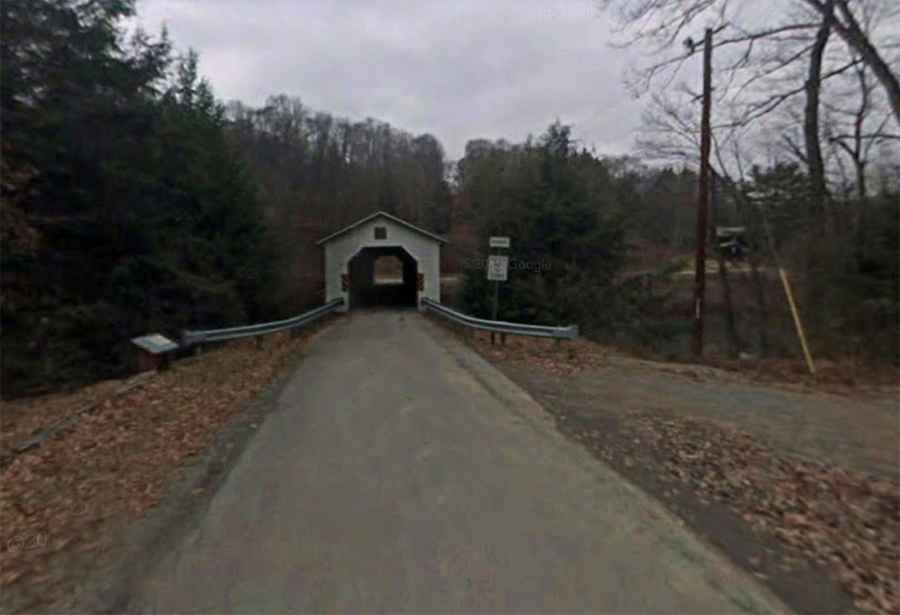
Why is the McGees Mills Covered Bridge a structural landmark?
Located at the start of the historic Susquehanna byway, the McGees Mills Covered Bridge is a prime example of 19th-century civil engineering still in operational use. Built in 1873 by Thomas A. McGee using hand-hewed white pine, this 122-foot single-span Burr arch truss bridge represents the last of its kind in the region. For modern drivers, crossing such timber structures requires an awareness of height and weight restrictions, as these historic links are vulnerable to environmental stress, including the heavy ice and snow loads typical of Pennsylvania winters. You might also want to check out the most spectacular bridges in the world.
How did geological processes form the Bilger’s Rocks corridor?
The area near Grampian features a unique geological formation known as Bilger’s Rocks, a 20-acre "rock city" created by a process called frost wedging. Over millions of years, water freezing in rock crevices caused massive boulders—some five stories high—to break away, creating a labyrinth of narrow caverns and deep fissures. Driving through this region offers a glimpse into the ancient periglacial environments that shaped the Appalachian landscape, though the terrain requires high-clearance vehicles for those venturing off the main paved byways.
What role does flood control play in Pennsylvania’s road logistics?
The creation of reservoirs like Curwensville Lake was a direct response to the devastating floods of the West Branch Susquehanna River basin. The construction of the Curwensville Dam in the mid-1950s—part of a massive federal flood control act—fundamentally altered local road logistics, rerouting historical tracks and creating new recreational access points. For the overland traveler, these reservoirs signify the intersection of hydraulic engineering and road development, providing essential staging areas for remote exploration.
Is it safe to rely on digital navigation in rural Pennsylvania?
In the remote Appalachian and township areas of Pennsylvania, digital GPS data can be notoriously unreliable due to the complex "municipality vs. mailing address" system. Travelers are strongly advised to carry physical, updated topographical maps. The lack of consistent cellular signal in deep mountain valleys and the presence of surprise on-ramps on older highways make manual navigation skills and a professional-grade tour guide or map essential for ensuring a safe transit through the Commonwealth's backcountry.
Conclusion: The Resilience of Pennsylvania’s Infrastructure
Exploring Pennsylvania by road is a journey through American industrial and geological history. While the pavement condition often reflects the state's budget challenges and harsh winters, the cultural and scenic rewards of its byways are unmatched. By maintaining mechanical readiness and respecting the structural limits of its historic bridges and dams, drivers can safely experience the diverse landscape of one of the nation’s most resilient infrastructure networks.