Glacier Peak: Driving the old mining road to the 3,917m summit
Glacier Peak is a high mountain summit at an elevation of 3,917m (12,851ft) above sea level, located on the boundary of Summit and Jefferson counties, in the US state of Colorado. Set high in the Front Range of the Rocky Mountains, the track to the top is an old mining road and stands as one of the highest roads in Colorado. The journey scales the alpine tundra of the Continental Divide, offering a raw driving experience through the historic mining districts of the region.
| Road facts: Glacier Peak | |
|---|---|
| Location | Summit / Jefferson Counties, Colorado, USA |
| Elevation | 3,917 m (12,851 ft) |
| Length | 4.5 km (2.8 miles) from Georgia Pass |
| Surface | Unpaved / Rocks and Mud |
Where is Glacier Peak located?
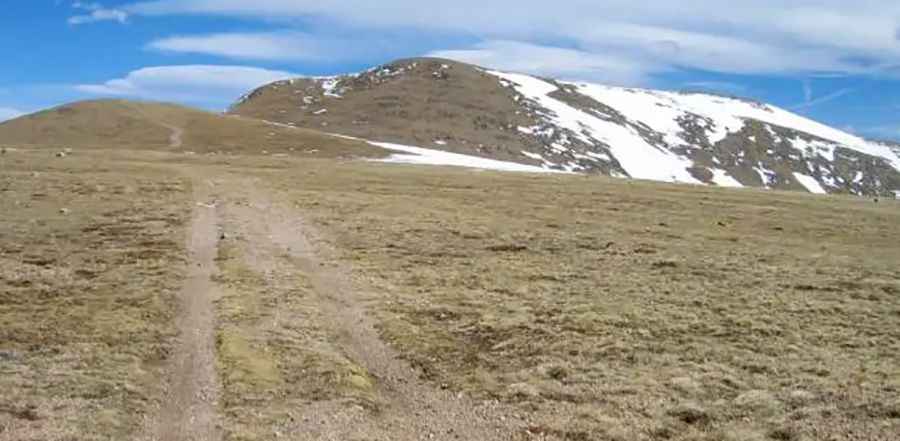
The peak is situated in the central part of Colorado, within the Arapaho and Pike National Forests. The access road starts from the well-known Georgia Pass and follows the ridge line toward the summit. This is a high-altitude wilderness area where the track stays above the tree line for much of its length. The nearest town for services and fuel is Breckenridge or Jefferson, but once you leave the pass, you are in a remote mountain environment with no facilities.
Is a 4x4 required to drive to Glacier Peak?
Yes, only high-clearance 4x4 vehicles or OHVs should attempt this climb. The road is an old mine track, often referred to as part of the Montezuma road system, and it is notoriously bumpy and rocky. You will encounter deep ruts, loose scree, and large embedded boulders that can easily damage the undercarriage of a standard SUV. The lack of oxygen at nearly 4,000 meters reduces engine power significantly, making it essential to have a low-range gearbox to manage the technical rocky sections without burning the clutch.
How steep is the road to Glacier Peak?
Starting from Georgia Pass, the climb gains 382 meters over a distance of 4.5 kilometers (2.8 miles), resulting in an average gradient of 8.48%. While the average seems manageable, the track features much steeper ramps on loose, unstable soil. The climb is a constant battle for traction, and if the ground is wet, the tires will easily spin and dig into the mud. From the summit, a secondary and even more challenging 4x4 trail heads east toward the top of Whale Peak.
Is the road to Glacier Peak open in winter?
No, the road is buried under deep snow for most of the year and is typically only accessible from July through September. Even in early summer, large snow drifts can block the north-facing slopes, and the trail is often impassable in the spring due to a persistent wet and muddy area on the upper sections. Sudden summer thunderstorms can turn the dirt into a slick slurry in minutes. You should check the cooling system and tire sidewalls before heading up, as a breakdown at this altitude means being stranded in a zone with extreme weather changes.
Is the road to Glacier Peak worth the drive?
The drive is worth it for those looking for a raw, high-altitude experience away from the crowded paved passes. The summit provides panoramic views of the Front Range and the South Park basin. Along the way, you pass through alpine meadows and remnants of the area's mining history. However, it is a long, bumpy ride that requires a vehicle in top mechanical condition. The descent is hard on the brakes; use engine braking and stay in low gear to avoid overheating the system on the steep, rocky drop back to Georgia Pass.
Pic: Jon Bradford