Driving the extreme mountain roads to San Juan Petlapa in Oaxaca
The Caminos de Sierra de Juárez, specifically the San Juan Petlapa Road, represent one of the most extreme geographical challenges in the Sierra Madre Oriental of Oaxaca, Mexico. Linking the Mexico 175 and 179 highways, this route is a relentless series of vertical climbs and descents that traverse deep canyons and high mountain passes. The road is a mechanical torture test, where the physical reality of driving involves shifting from the high-altitude cold of Cuajimoloyas at 3,170 meters to the tropical heat of San Juan Petlapa at 660 meters in just a few dozen kilometers of technical, narrow track.
| Road facts: San Juan Petlapa Road | |
|---|---|
| Location | Sierra de Juárez, Oaxaca, Mexico |
| Max Elevation | 3,170m (10,400ft) at Cuajimoloyas |
| Min Elevation | 660m (2,165ft) at San Juan Petlapa |
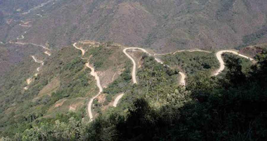
| Technical Feature | 40 switchbacks in a 10km canyon sector |
How challenging are the elevation shifts on the Sierra de Juárez roads?
The logistics of driving to San Juan Petlapa are dominated by extreme elevation gains and losses. Starting near Villa Díaz Ordaz at 1,720 masl, the road ascends dramatically to the town of Cuajimoloyas, reaching 3,170 masl in just 20 kilometers of high-grade climbing. This is followed by a brutal descent to the Yalalag river at 850 masl. For a vehicle, this means the cooling system must manage the thin air at the summit while the braking system faces a massive thermal load during the 2,300-meter drop. The engine aspiration fluctuates constantly, requiring a motor in perfect condition to handle the oxygen-starved climbs and the high-pressure descents.
What are the main hazards on the road to San Juan Petlapa?
The primary hazard is the concentration of tight switchbacks and unstable canyon terrain. Between San Cristóbal Lachirioag and San Juan Tabaá, the road performs over 40 switchbacks in a single 10-kilometer stretch. The track is narrow and often rough-paved or unpaved, with no safety barriers protecting against the deep canyon drops. Landslides are a constant physical reality in the Sierra Madre Oriental, and the road can be partially blocked by fallen rocks or washed out by mountain runoff. Encountering local furgonetas or heavy transport on these blind turns requires precision steering and immediate stopping power on surfaces that offer minimal grip.
What is the current state of the road infrastructure in Oaxaca?
While some sections near the main towns are rough-paved, the infrastructure remains primitive. In the sector towards San Juan Petlapa, the road narrows down significantly as it descends from a 2,400m mountain pass to the town at 660m. There are ongoing construction efforts, such as the section towards Jocotepec, but these often mean driving through raw earth and loose gravel. The historic arched bridge at the Yalalag river is now reserved for pedestrians, with a modern bypass handling vehicle weight, but the secondary roads leading to small settlements like San Andrés Yaá remain high-isolation sectors where mechanical help is hours away.
What mechanical prep is needed for the 3,170m Oaxaca crossing?
Before leaving the Mexico 175 or 179 highways, verify that your braking system—specifically the pads and fluid—is at 100% capacity. The 2,000-meter vertical descents are a torture test that can boil old brake fluid instantly. Check your tire tread and pressures; the sharp rocks and varied surfaces of the Sierra de Juárez require high-grip tires. Ensure your cooling system is flushed and functional to handle the high-rev climbs in thin air. Carry at least 20 liters of extra fuel and 15 liters of water, as fuel consumption on these switchback-heavy routes is much higher than on standard roads. In this remote part of Mexico, self-sufficiency and a high-clearance 4x4 are the only ways to guarantee a safe arrival in the deep canyons.
Road suggested by: Eblem Torres
Pic: Lon&Queta