Morelos Road
Carretera a Morelos is a very dangerous, long, tedious, unpaved/gravel route to town of Morelos in Chihuahua state.
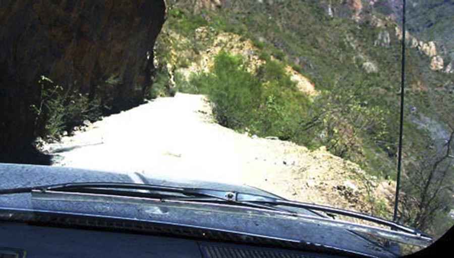
This town is so isolated for the rest of the world that few years ago in 2008 electricity just arrived to town, mainly because is a hidden town in the rugged mountains, almost impossible for any road, power line to traverse, the only fastest way to get to Morelos is by airplane but even if your plane lands safely because the landing strip is only 500 meters long in a step mountain, other than that if you are crazy enough to traverse the only road to the town, add the danger than falling into a canyon, being kidnapped or killed for crossing a drug plantation area or for bad weather common in the area, mudslides, rough road, flash flooding or even wild animals makes this a great challenge for anyone. This road is very scenic, offers one of the most incredible views of deep and huge canyons of Sierra Madre, bigger than the Grand Canyon of Colorado, the Copper Canyon, this road, test the skills and gluts of any driver around the world.
Departing from near from Batopilas at 570 masl, the road dramatically goes up into the mountains in a series of switchbacks to town Buenavista located at 2400 masl, over 1800 meters in sea level change in just less than 20 kilometers. The road stays for 20 kilometers in a mesa, near Los Chiqueros, the road starts to descend to Polanco at 1400 masl and continues descending into the San Miguel river bottom of the canyon at 410 masl in just 30 kilometers, passes the river and again ascends to 1140 masl to finally arrive at Morelos at 580 masl.
Road suggested by: Eblem Torres
Pic: jpapineau