Driving the Longest Road in Greenland: The Arctic Circle Road from Sisimiut to Kangerlussuaq
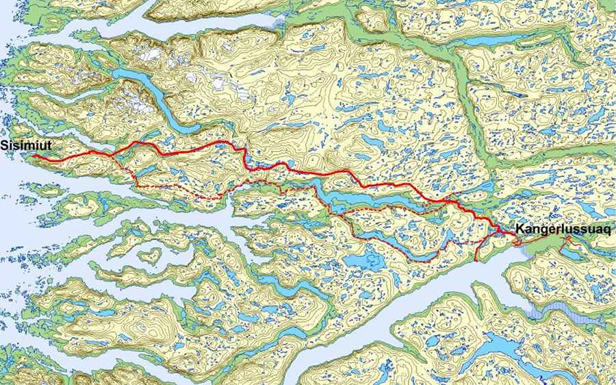
The Arctic Circle Road is situated in western Greenland, connecting the inland town of Kangerlussuaq to the coastal town of Sisimiut. This track represents a significant infrastructure development in one of the world's most challenging and sparsely populated environments.
What is the Arctic Circle Road?
This groundbreaking infrastructure project distinguishes itself from conventional paved roads found in most countries as it's designed specifically for off-road vehicles, primarily 4x4s, ATVs, and snowmobiles in winter.
How long is the Arctic Circle Road?
The Arctic Circle Road is an unpaved gravel track stretching approximately 170 kilometers (106 miles).
Why was the Arctic Circle Road built?
This overland connection has been a long-discussed necessity. Its primary motivations included:
- Enhancing Connectivity and Livelihoods: The road links Kangerlussuaq, Greenland's major international transport hub (home to its main airport), with Sisimiut, the second-largest city in Greenland and the largest Arctic city in North America. This connection aims to improve the livelihoods of residents and provide better opportunities for business sectors through cheap, flexible, and independent transportation, opening up the land between the two towns.
- Facilitating Trade: It will allow exporters of fresh fish from the Sisimiut region to truck shipments to Kangerlussuaq Airport for flights to European and other markets. This significantly reduces transport time (estimated 2.5-3 hours by truck compared to relying on slower frozen fish exports by sea) and facilitates easier imports of goods from Denmark and other markets.
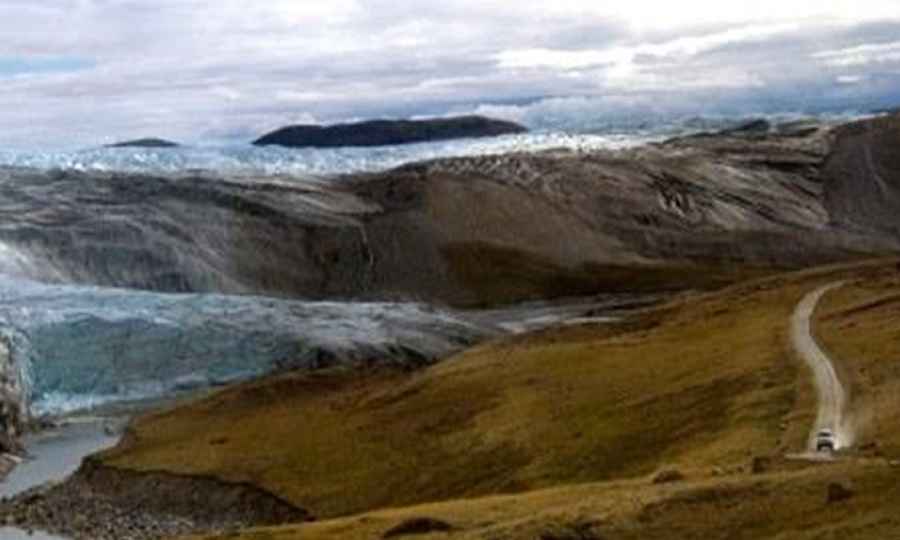
- Supporting Tourism and Outdoor Activities: The track opens new avenues for adventure tourism, including hiking, fishing, hunting, and off-road expeditions, providing easier access to the Greenland Ice Sheet from Sisimiut.
- Cost-Effectiveness: Building a fully paved road across Greenland's rugged, permafrost-affected terrain would have been prohibitively expensive and technically challenging. The 4x4 track offered a more feasible and cost-effective solution.
When was the Arctic Circle Road built and opened?
Construction of the Arctic Circle Road began in 2018, and the track was officially inaugurated in December 2021.
What were the construction challenges for the Arctic Circle Road?
The project faced significant logistical and environmental hurdles:
- Complex Terrain and Material Sourcing: The route crosses diverse and challenging landscapes, including mountains and hilly terrain up to 500 meters high. This necessitated extensive rock blasting and the opening of new mines along the route to extract suitable construction material, a process often more extensive than the road construction itself. Loose, suitable soil layers are rare, with predominantly patches of rock and wet soil.
- Permafrost: The presence of permafrost means the top layer of soil is constantly moving, posing unique engineering challenges.
- Remote Location: All equipment and materials had to be transported by sea or air.
- Short Construction Season: Work was largely limited to the brief Arctic summer months.
Who can use the Arctic Circle Road?
The Arctic Circle Road is not a public road in the conventional sense and does not facilitate standard passenger car traffic. Its primary users are:
- Local residents for recreational purposes or specific transport needs.
- Tour operators running guided 4x4 tours, hiking expeditions, or snowmobile trips.
- Researchers and others needing access to remote areas.
- Commercial freight for fish exports and general imports.
When can I drive the Arctic Circle Road?
The track is expected to be usable by wheeled vehicles for eight months out of the year. Due to the harsh Arctic climate, conditions can change rapidly, with snow, ice, and strong winds frequently affecting road usability.
- Summer: Accessible by 4x4 vehicles, though conditions can still be challenging with mud, river crossings, and varying surface quality.
- Winter: Primarily used by snowmobiles and dog sleds, as heavy snow makes it impassable for wheeled vehicles.
How many vehicles are expected to use the Arctic Circle Road?
By 2030, it's projected to see up to 1,600 vehicles annually, with the peak travel season experiencing as many as 35 road vehicles and 15 ATVs per day.
Pic&map: http://dl.polarrouten.net/files/atv-natureroad.pdf