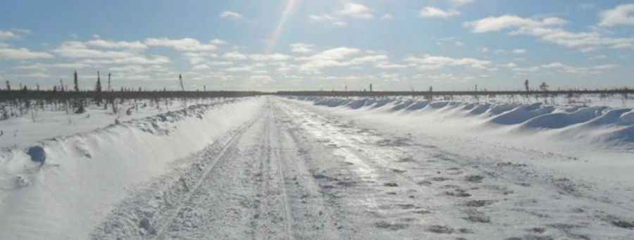
Wapusk Trail is the longest seasonal winter road in the world
Located in the geographical heart of Canada, near the tree line on the edge of Hudson Bay, the Wapusk Trail is recognized by the Guinness World Records as the longest seasonal winter road in the world. Careful preparation for your trip will ensure that if, and when, things do go wrong, you are prepared for the situation.
When is Wapusk Trail built?
Every January, the road is painstakingly constructed on snow and ice to provide temporary access for a few weeks to remote settlements surrounding Hudson Bay. These settlements, which are typically only reachable by air, rely on this road until the arrival of warmer March weather necessitates its closure. Designed in cold conditions, the road is strategically laid out, following the path of least resistance and traversing natural terrain features like muskeg, lakes, rivers, and creeks. These winter roads play a crucial role in facilitating transportation during the winter, connecting isolated areas where permanent or all-weather roads are absent. Unfortunately, the increasing brevity of the seasons poses significant challenges. It is becoming progressively more arduous to construct reliable ice roads as they are highly dependent on the unpredictable thickness of the ice. As an alternative, air transportation is available, albeit at a considerable cost.
How long is Wapusk Trail?
The road is 772 km (479 miles) long and stretches west from the communities of Shamattawa and Gillam in Manitoba and east to Peawanuck. In 2011 the road was made a bit longer, arriving to Winisk. The road runs 252 km from Peawanuck to Fort Severn, 234 km from Fort Severn to the Manitoba border, 90 km from the border to Shamattawa, and 196 km from Shamattawa to Gillam. The first 90 km of the road west from Fort Severn is the worst part of the road when the wind is blowing. The number of trucks averages between 30 to 40, with 44 trucks being the record number of trucks in one year, transporting consumer goods, fuel and construction materials. This type of ‘temporary highways’ have a crucial role in enabling goods to be delivered to communities without permanent road access.
When was the Wapusk Trail constructed for first time?
The winter road system dates back to the 1950’s built by private construction companies to provide a means of transporting freight to isolated northern communities that would be less costly than air transport. The trail has been featured in Ice Road Truckers TV show.
How long does it take to drive the Wapusk Trail?
It takes about 12 to 17 hours to complete the drive, depending on the conditions.
How to prepare to drive the Wapusk Trail?
Due to the remoteness of the area, take special care to ensure that your vehicle is ready for the trip. You need to be prepared. In case of a breakdown, there is very little in the way of passing traffic or inhabitants around, and no cell phone service in parts. Winter survival and communication equipment are recommended. Take emergency supplies and extra parts; make sure you know your route. Know where you are and know where you are going.
Pic&more info: https://www.tvo.org/article/since-ice-roads-wont-stay-frozen-we-need-to-get-serious-about-building-permanent-roads-in-the-far