Pan-American Highway, the longest road in the world
The challenging Pan-American Highway is one of the biggest adventures in the world. It’s a network of roads covering almost 30,000 kilometres (19,000 mi) from North America to South America. It’s said to be the longest road on Earth.

What’s the Pan-American Highway?
Pan-American Highway is the name given to a network of roads running from North America to South America through 14 countries. The northern part of the road goes through Canada, United States, Mexico, Guatemala, El Salvador, Honduras, Nicaragua, Costa Rica and Panama. The southern part crosses Suriname, Guyana, Brazil, Venezuela, Colombia, Ecuador, Peru, Chile, Argentina, Bolivia, Paraguay and Uruguay. No road in the U.S. or Canada has been officially designated as the Pan-American Highway.
How long is the Pan-American Highway?
The road is about 30,000 kilometres (19,000 mi) long. It’s said to be the longest road on Earth. The trip offers the most diverse scenery on the planet—and plenty of pit stops. Driving the Pan American Highway is probably the most popular overland route in the world. The road is not often traveled in its entirety. There are many branches that allow you to cover the full Arctic to almost Antarctic distance, adding up to a whopping 30,000miles (48,000km) in total.
Where does the Pan-American Highway start and end?
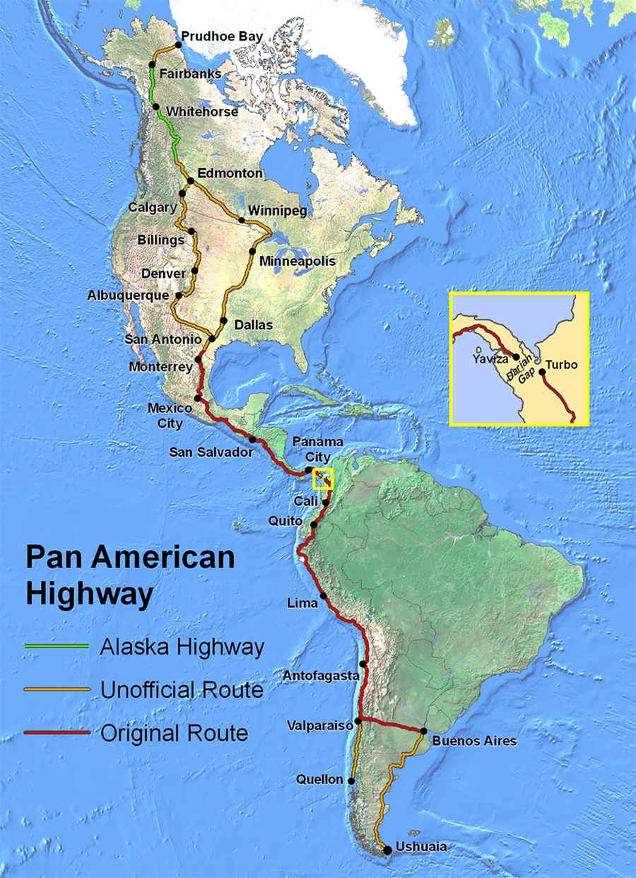
The Mother of All Road Trips starts from Prudhoe Bay, Alaska, and stretches south to the tip of Argentina in Ushuaia (Tierra de Fuego) to the lower reaches of South America. The ultimate road trip tops out at 3.451m (11,322ft) above the sea level at Cerro de la Muerte, what is considered the highest point of the road.
Can you really drive from Alaska to South America?
The connection from North America and South America can be done by vehicle less in Darien Gap, where is necessary to take a ferry. The gap is 60 miles (96 km) long and 50km wide, stretching from the Atlantic to the Pacific, on the border between Panama and Colombia. The gap consists of undeveloped swampland and impenetrable rainforest inhabited by indigenous tribes, Colombian guerrillas and an array of exotic wildlife.
Is the Pan-American Highway safe?
The travel is a real adventure, and there are a lot of risks. High temperatures, landslides, steep drop-offs, livestock in the road and impassable sections during the wet season. Due to the extreme winters, it's advisable to avoid winter at the extreme North and South ends of the journey. That naturally means the journey is often completed in approximately one and a half years. Try to avoid areas where cartels operate. Follow the advice for the area you are at. There are many dangers, like wild animals, forests, swamps, and there might even be dangerous criminals hiding in the forests or the swamps. The highway passes through many diverse climates and ecological types, from dense jungles, to arid deserts, some of which are passable only during the dry season, and in many regions driving is occasionally hazardous. The landscape really tests drivers skills, as the road runs through mountains, jungles, deserts and glaciers.

Map: By Created by en:User:Seaweege and released to PD - Own work, Copyrighted free use, https://commons.wikimedia.org/w/index.php?curid=1503793