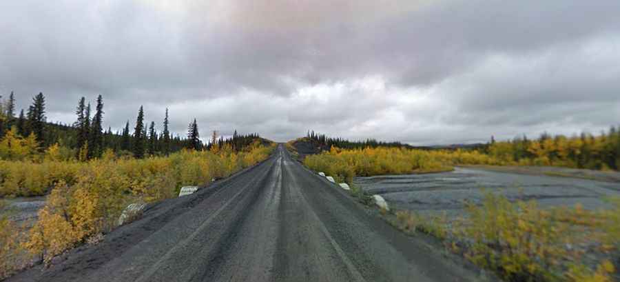
Dempster Highway is a Top Canadian Drive to the Arctic
Running across miles of desolate Arctic landscape in Canada, Dempster Highway is the only all-weather road to cross the Arctic Circle.

What is the Dempster Highway?
The drive, a truly memorable driving adventure, is incredibly beautiful, somewhat dangerous, and perhaps something you get to see only once (if that) in your life. If your ideal road trip involves getting way off the beaten track, then this is the drive for you.
Where does the Dempster Highway begin and end?
The road runs from the Klondike Highway (east of Dawson City in Yukon) to Inuvik (in Northwest Territories on the Mackenzie River delta). It’s 736 km (457 mi) long. As of November 2017, Dempster Highway travelers can drive an additional 147 km (91 miles) on NWT Highway 10 to Tuktoyaktuk. NWT Highway 10, known as Inuvik to Tuktoyaktuk Highway, is the "first all-weather road to Canada's Arctic Coast." This new road starts at Inuvik, passing through the tree line, onto the tundra and ending at the Arctic Ocean in Tuktoyaktuk (Tuktuyaaqtuuq), a hamlet located in the Inuvik Region of the Northwest Territories. The highway crosses the Peel River and the Mackenzie Rivers using a combination of seasonal ferry service and ice bridges.
Is the Dempster Highway paved?
Appropriate preparation is essential to having a safe, enjoyable trip on this two-lane road, also referred to as Yukon Highway 5 and Northwest Territories Highway 8. It’s a well-maintained gravel and crushed stone road. Road conditions can also vary drastically as it winds its way through two mountain ranges, the Oglivie and the Richardson; crosses the Continental Divide three times; traverses the Arctic Circle and loosely follows the old dog team routes on its way to Inuvik and the Mackenzie Delta. The highway can be dusty in the summer. It should be driven in a vehicle with good clearance and a spare mounted tire.
When was the Dempster Highway built?
Construction of the Dempster Highway began in 1959 and was finally completed in 1978, although it did not officially open until Discovery Day weekend in 1979. It follows a route traditionally used by Indigenous people for thousands of years and was named for Inspector William John Duncan Dempster of the North-West Mounted Police.
Is the Dempster Highway Safe?
An enjoyable, safe journey up the Dempster Highway involves careful planning. Ensure you have good spare tires and do some basic vehicle maintenance. Be prepared with jackets, water, and an emergency kit in your car. Check in Dawson City, or at the Klondike River Lodge (at the junction of Klondike and Dempster Highways) for road conditions before beginning your trip. Signs at Eagle Plains remind you to check conditions again before venturing beyond that location. Services are limited: gas, diesel fuel, and repairs are available at Eagle Plains 365.7 km/227 miles, Ft. McPherson 555 km/345 miles, and at Inuvik. Be prepared to stop for approaching trucks, especially in dry, dusty conditions. You have to drive according to the conditions of the road. The speed limit is 90 KM/Hour, which can be done the majority of the time. Facilities are few and far between. It is strongly recommended to carry a full-sized spare tire as well as extra water and gas. Traffic will be very light so you must come well prepared. In the winter, carry a shovel, sleeping bag, stove, matches, emergency snacks, and, of course, dress for cold outdoor temperatures. It would be wise to rent a satellite phone as cell service is not available in some areas along the route.
Is the Dempster Highway open?
This is a mountain road, topping out by North Fork Pass Summit, at 1.328m (4,356ft) above sea level. It’s open approximately from June 10 to October 14 in the summer, and December 15 to April 30 in the winter.
How long does it take to drive the Dempster Highway?
This unpaved road traverses some of the most beautiful scenery on the planet. It’s one of northern Canada's undiscovered, yet readily accessible wonders, offering incredible scenery, wide-open spaces, and remote beauty. This wilderness route spans remote regions of the Yukon, cutting through two rugged mountain ranges, the Ogilvie and Richardson Mountains, miles of stunted spruce and alder "forests" (8'-12' tall) in the Eagle Plains region, and elevated reaches of tundra before dropping to the Mackenzie River and its flat aspen-covered delta. The journey takes at least two days. Count on driving 12 to 16 hours in each direction. The time it takes depends on road conditions and how often you stop along the way.
When is the best time to drive the Dempster Highway?
It is an out-of-this-world experience. Should you wish to embark on a summer journey, consider any period from late June to early August. If an autumn drive captures your interest, opt for any time from early August to early September. During the summer months, it is the land of the midnight sun with 56 days of 24-hour sunlight.