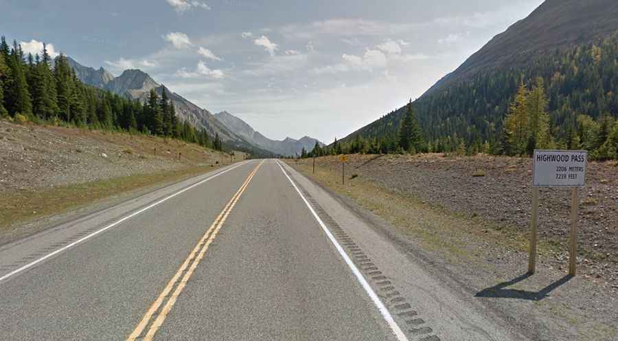
Highwood Pass is the highest paved road of Canada
Highwood Pass is a high mountain pass at an elevation of 2,217m (7,273ft) above sea level, located in Kananaskis Country, in the Alberta province of Canada. It’s said to be the highest paved road in the country.
Where is Highwood Pass?
The pass is located only 140 km southwest of Calgary, in the Peter Lougheed Provincial Park, just south of Lower Kananaskis Lake, in the Alberta province, on the western part of the country.
Where does Highwood Pass start and end?
The road to the summit is totally paved. It’s called Alberta Highway 40. The road is 148 km (92 miles) long, running from Kananaskis to Longview.
How hard is Highwood Pass?
Ice and snow can be on the way. The road is steep, hitting a 7% of maximum gradient through some of the ramps. Be prepared to encounter bears.
Is the Highwood Pass open?
Set high in Alberta’s Rocky Mountain Front Ranges, this road is usually closed from December 1 through June 15, due to very high snowfall and for the migration of wildlife. The summit is just about at the tree line, which means the surrounding area is one of the most accessible alpine areas in the Canadian Rockies. The summit of the pass is notoriously windy, and mountain weather changes quickly.
How long does it take to drive the Highwood Pass?
Plan about 1.5-2 hours to complete the drive without any stop. However, the road rewards the drivers with one of the most varied and picturesque drives of the country. This drive can take a full day with stops and activities.