What are the driving hazards of the road to Mount Buchanan Lookout in BC?
The Mount Buchanan Lookout is a high-altitude observation point at an elevation of 1,910m (6,266ft) above sea level in the Selkirk Mountains of British Columbia. This historic site, located ninety minutes from Nelson in the Central Kootenay region, represents a critical intersection between forestry history and high-mountain logistics. Accessing the summit requires navigating a 10.9 km unpaved route with a sustained 10.7% average gradient.
| Road facts: Mount Buchanan Lookout | |
|---|---|
| Location | Central Kootenay, BC (Canada) |
| Elevation | 1,910 m (6,266 ft) |
| Length | 10.9 km (6.77 miles) from BC-31A |
| Average Gradient | 10.7% |
| Max Gradient | 15% in specific ramps |
What is the history and technical evolution of the Buchanan Lookout?
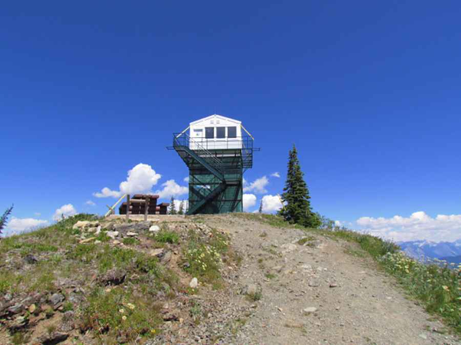
The facility was initially established in the early 1940s as a braced-pole structure with a viewing platform. Logistically, the site's development was an immense challenge; in 1949, a pre-fabricated 14'x14' wooden tower had to be transported up the mountain by packhorses. It wasn't until 1958 that a functional access road was constructed to allow truck transit. In 1965, the infrastructure was upgraded to an 18-foot concrete block tower, which remained operational for fire detection until 1982. Today, the tower is staged as a museum reflecting its active years as a forestry office, though the interior remains locked for preservation.
What are the driving challenges of the 10.7% gradient on the BC-31A spur?
Starting from the paved BC-31A road, the 10.9 km route is completely unpaved, narrow, and involves an elevation gain of 1,167m. Technically, the road is categorized as a high-clearance 2WD route, but the brutally steep sections and loose surface demand constant traction management. The trail features multiple tight switchbacks designed to mitigate the verticality of the Selkirk Mountains. Drivers must be cautious of the limited pull-outs for passing; encountering oncoming traffic often necessitates reversing maneuvers on unbanked, steep slopes with significant exposure.
How to manage vehicle mechanics during the Mount Buchanan descent?
The 1,167m descent is a test of the vehicle's braking thermal capacity. Technically, the 10.7% gradient is steep enough to induce brake fade within the first few kilometers if the service brakes are not managed correctly. Safety protocols mandate a stop-and-cool strategy at the mid-point of the descent. It is essential to utilize engine braking in a low gear to control speed through the hairpins. The summit provides tactical views of Kootenay Lake and Kokanee Glacier Provincial Park, but the drive itself requires full mechanical focus on tire sidewall integrity and cooling system performance.
Pic: North Okanagan Outdoors