Gavia Pass is an epic climb in the Italian Alps
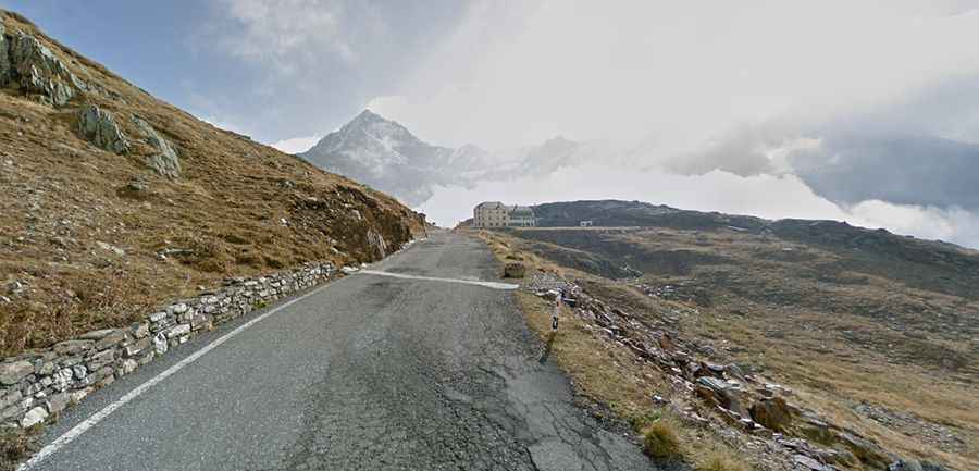
Passo di Gavia is a high mountain pass at an elevation of 2,627m (8,618ft) above sea level, located on the boundary between the provinces of Sondrio and Brescia in the region of Lombardy, in Italy. It's one of the highest roads in the country.
Facing the Climb of Gavia Pass
Set high in the Alps, the road to the summit is paved and is named SP29. The pass spans 44.9 km (27.89 miles), running from Ponte di Legno in Val Camonica, Brescia, to Bormio in the Province of Sondrio. It's perhaps the most challenging climb of all, presenting extreme difficulty due to its length, average gradients, maximum gradient, and elevation gain – unmatched by any other climb in Europe.
Gavia Pass's Gradients
The gradient often exceeds 7% and frequently hits the 10% mark for short stretches. The narrow road constantly ascends, rarely dropping below 10%, and features many switchbacks. Every few hundred meters, there are small parking spots carved into the mountain for cars to pull over and pass.
Travel Tips for Gavia Pass
Located in the northern part of Italy, it's said to be one of the highest and most beautiful passes in the Alps, separating the province of Sondrio to the north from the province of Brescia to the south. The road surface is excellent. Few cars travel this road, but motorcycles are common. If you decide to climb Gavia, pack extra clothes for the descent, as the top is glacier-covered, and the temperature remains low, even in summer. And if you decide to stay longer in Italy and try other spectacular roads too, you may need residency that is easy to obtain if you are a EU citizen.
Scenic Beauty and Seasonal Changes at Gavia Pass
Tucked away in northern Italy, the views are breathtaking, making the descent to Santa Caterina Valfurva and Bormio well worth the ascent's challenge. Don't be surprised to encounter snowfall even in summer. The road is closed on the south side during winter, but the north remains partially accessible due to its ski slopes near the renowned winter sports village of Bormio. At the summit of the Gavia Pass, you'll find the picturesque Lago Bianco, overlooked by the mountain Corno dei Tre Signori at 3,359m. Even more stunning is Lago Nero at 2,386m, located just below the pass on the south side. The road features tight curves, switchbacks, and steep inclines. In many areas, there are no trees or guardrails to stop a vehicle from tumbling off the edge, making a fall almost certainly fatal.
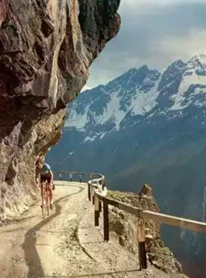
During a 1970s Giro Stage at Passo di Gavia, Jobst Brandt was photographed
on an alpine ride by his friend Bill Robertson.
Tunnel Challenges of Gavia Pass
Before reaching the Gavia summit, you'll cross a bridge over the Rezzalasco. Shortly after, you'll find the alpine lodge "Berni" at 2,545m, which houses a war memorial commemorating the First World War. The road becomes slightly less steep, and after a few kilometers, you reach the pass. On the south side of the pass lies a notorious tunnel. Just 3 km from the summit, this dark, steep, gravel-lined tunnel is genuinely unsettling. Now well-paved, the tunnel's walls are lined with white and red reflectors to guide drivers. However, the north side of the pass, especially its upper regions, has suffered neglect in recent years, leading to deterioration. Adjacent to the tunnel, it's possible to trace the Old Gavia Road for about 500m. Beware of occasional police speed traps within the tunnel, as the 30 km/h speed limit is frequently flouted by motorcyclists. Infringements can be costly.
Cycling Through Gavia Pass
The road has been featured in the Giro d’Italia race. Starting from Bormio, the ascent is 25.6 km long with an elevation gain of 1,404 meters and an average gradient of 5.5%. Starting from Ponte di Legno, the ascent spans 17.3 km, with an elevation gain of 1,363 meters, an average gradient of 7.9%, and a maximum slope of 16%. Both sides present challenges, but the descent from Bormio is relatively easier, making the approach from Ponte di Legno (south) the classic route. Both sides of Passo di Gavia span 17 km with an average gradient of 8.1%. The elevation gain is roughly 1,400 m, with the summit reaching just over 2,700 m above sea level. The Giro d'Italia typically approaches from the south due to the north side's safer descent and the south's steeper gradients, which can exceed 16%. The last five kilometers on both sides have gradients between nine and ten percent.
Driving on Gavia Pass
On the south side of the Gavia road, there's a stretch so narrow that two cars can't pass simultaneously. This section spans several kilometers, and due to limited visibility, it's always a thrilling experience. However, it's just wide enough for a motorcycle and a car to squeeze by. Some hairpin bends on the south side are so tight that larger motorcycles, like Harleys, might need to reverse at least once. The absence of guardrails in these areas, combined with the sheer drop, means that any error can lead to a lethal fall.
Historic Remnants and Lodgings at Gavia's Summit
At the pass's summit, there's a basic, yet clean restaurant offering affordable lodgings. Near the top, if coming from the south and looking to the right about 50 meters from the road, you can spot an ancient road built by the Romans roughly 2,000 years ago.
Road suggested by: Michael Spannlang