How to get to Stwlan Dam in Wales?
Llyn Stwlan is a mountain reservoir at an elevation of 512m (1,679ft) above sea level, located in the county of Gwynedd, in Wales.
Where is Stwlan Dam?
Built in 1957, the Ffestiniog Power Station is located within Snowdonia National Park, in the northwest part of the country.
How do you get to Stwlan Dam?
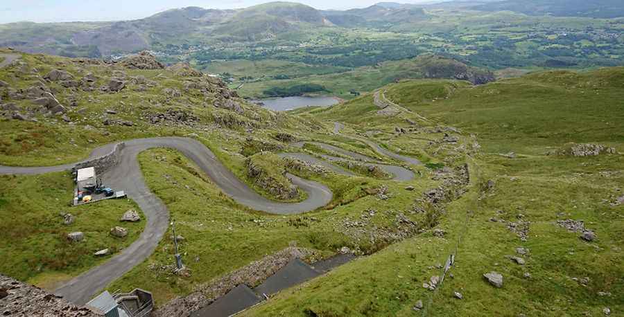
The road to the dam is entirely paved but narrow and curvy, with 8 hairpin turns. Starting at Tanygrisiau, the road to the dam is 2.89km (1.8 miles) long.
Is the road to Stwlan Dam open?
The road is closed to private vehicles. Chains or snow tires may be required at any time. At the top, the views of the Moelwyn range and the Vale of Ffestiniog are outstanding. Llyn Stwlan was a small corrie lake until the late 1950s when the dam was built as part of the Ffestiniog Hydro-Electric pumped storage scheme. Lying at 1,600 feet above sea level in the Moelwyn mountains, Stwlan is the top reservoir from which the water drops 1,000 feet to turn turbines at the Ffestiniog Power Station.
Is the road to Stwlan Dam steep?
The road to the summit is very steep, with a maximum gradient of 18.4% through some of the ramps. Starting at Tanygrisiau, a village within Blaenau Ffestiniog in the upper end of the Vale of Ffestiniog, the ascent is 2.89km (1.8 miles) long. Over this distance, the elevation gain is 279 meters. The average gradient is 9.65%.
Pic: Gareth Jones