How difficult is the steep gravel road to Kavakdağı Tepesi in Turkey?
Kavakdağı Tepesi is a high mountain peak reaching an elevation of 2,428m (7,965ft) above sea level in the Erzurum Province of Eastern Anatolia. The climb to the summit is a short but brutal transition from the main highways into the raw, unmaintained terrain of the Turkish highlands. The track is a rugged gravel path that serves as a secondary access route, where the thin air and the loose surface turn a simple drive into a test of traction and mechanical limits for any vehicle attempting the ascent.
| Road facts: Kavakdağı Tepesi | |
|---|---|
| Location | Erzurum Province, Turkey (Eastern Anatolia) |
| Elevation | 2,428 m (7,965 ft) |
| Length | 3.1 km from Gölyurt Geçidi |
| Max Gradient | 12% |
| Surface | Rough Gravel / Loose Stones |
How do you reach Kavakdağı Tepesi from the D925?
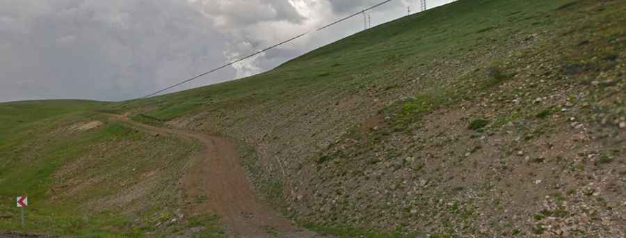
The journey begins as a turn-off from the Gölyurt Geçidi on the D925 highway. From this high mountain pass, the road to Kavakdağı Tepesi spans just 3.1 kilometers (1.9 miles). While the distance is short, the elevation gain of 78 meters is concentrated in several steep ramps where the gradient spikes to 12%. On a loose gravel surface, a 12% incline is enough to cause significant wheel spin. The track is narrow and features sharp hairpin turns where the edges are often soft and prone to crumbling, requiring a slow and steady pace to avoid sliding off the track.
Why is a high-clearance 4x4 mandatory for Kavakdağı Tepesi?
Attempting this climb in a standard passenger car is a mistake that often ends with a damaged oil pan or a burnt-out clutch. The rocky substrate of the Erzurum mountains is unforgiving; large, jagged stones frequently surface in the middle of the ruts, making high ground clearance essential. You need a 4x4 with a low-range gearbox to maintain constant torque on the 12% ramps without having to rely on speed, which would only cause the tires to lose grip on the unpaved ground. The thin air at nearly 2,500 meters also reduces engine power, making the mechanical strain even more apparent as you approach the peak.
When is the best time to drive to the Kavakdağı Tepesi summit?
Due to its high altitude in Eastern Anatolia, the road to the summit is completely blocked by heavy snow for more than half the year. It is generally impassable from late October until early June. Even in the summer months, the weather around Erzurum is unpredictable; sudden storms can turn the dry gravel into a muddy slide in minutes. High winds at the 2,428m summit are common, often blowing debris across the narrow hairpins. Before leaving the D925, check for low cloud cover, as visibility on the exposed ridges can drop to zero, making the steep descent back to the highway extremely dangerous.
What are the hazards of descending from Kavakdağı Tepesi?
The descent is as technical as the climb. The 12% gradients on loose gravel put a massive load on the vehicle’s braking system. Relying only on the foot brake can lead to overheating and brake fade before you even reach the halfway point of the 3.1 km drop. Using engine braking in low gears is the only safe way to manage your speed. Watch out for the outer edges of the hairpins; the gravel here is often uncompacted and can give way under the weight of a heavy 4x4. Keeping the vehicle centered in the ruts and maintaining a crawl is the only way to stay stable on the uneven and shifting surface of the mountain.