Akçaağıl Gölü: Driving the high-altitude glacial track in Rize
Akçaağıl Gölü is a high mountain pass at an elevation of 3,107m (10,193ft) above sea level, located in Turkey. It is one of the highest mountain roads of Turkey.
| Road facts: Akçaağıl Gölü | |
|---|---|
| Location | Rize / Bayburt border, Turkey |
| Elevation | 3,107 m (10,193 ft) |
| Length | 34.5 km (Yoncalı to Yazyurdu) |
| Surface | Unpaved / Natural mountain soil |
Where is Akçaağıl Gölü?
The pass is located on the boundary between the Rize and Bayburt provinces, in the northeastern part of the country, near the Küçük Akçaağıl Gölü, a glacial lake sitting just below the summit. It separates the Black Sea watershed from the Anatolian interior.
Is the road to Akçaağıl Gölü unpaved?
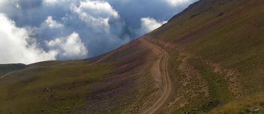
The road is entirely unpaved and the surface consists of natural mountain earth and loose stones. It is a primitive cut into the mountain face. In several sections, the track is barely wide enough for one vehicle, with soft shoulders and steep unprotected drops on the downhill side.
How long is the road to Akçaağıl Gölü?
The road is 34.5 km long and runs north-south, from Yoncalı to Yazyurdu. Although the track is used by local traffic, a high-clearance vehicle is required.
Is the road to Akçaağıl Gölü open in winters?
Set high in the rugged Pontic Mountains, the road is totally impassable for more than half the year. Heavy snow blocks the route from October until late June. Even during the summer months, the road is subject to rapid weather changes. Sudden fog (common in the Pontic Alps) is common. The road is often saturated with water from melting snow patches even in mid-summer and it can be blocked anytime by rockfalls from the crags above.
Pic: Doğanın Sırdaşları