Driving the steep and dangerous Kemer Dağı pass in Bayburt
Kemer Dağı is a high mountain pass at an elevation of 2,582 meters (8,471 ft) above sea level, located in the Aydıntepe District of the Bayburt Province, Turkey. Situated in the rugged Pontic Mountains, this pass is a critical and technical link between Kavlatan and Suludere. Although the 27-kilometer route was recently paved, the physical reality of driving here is defined by extreme altitude shifts and an unstable geography where the road is constantly under threat from the surrounding rock faces.
| Road facts: Kemer Dağı | |
|---|---|
| Location | Aydıntepe, Bayburt, Turkey |
| Elevation | 2,582m (8,471ft) |
| Length | 27 km (16.8 miles) |
| Hairpin Turns | 12 |
How challenging is the drive to Kemer Dağı?
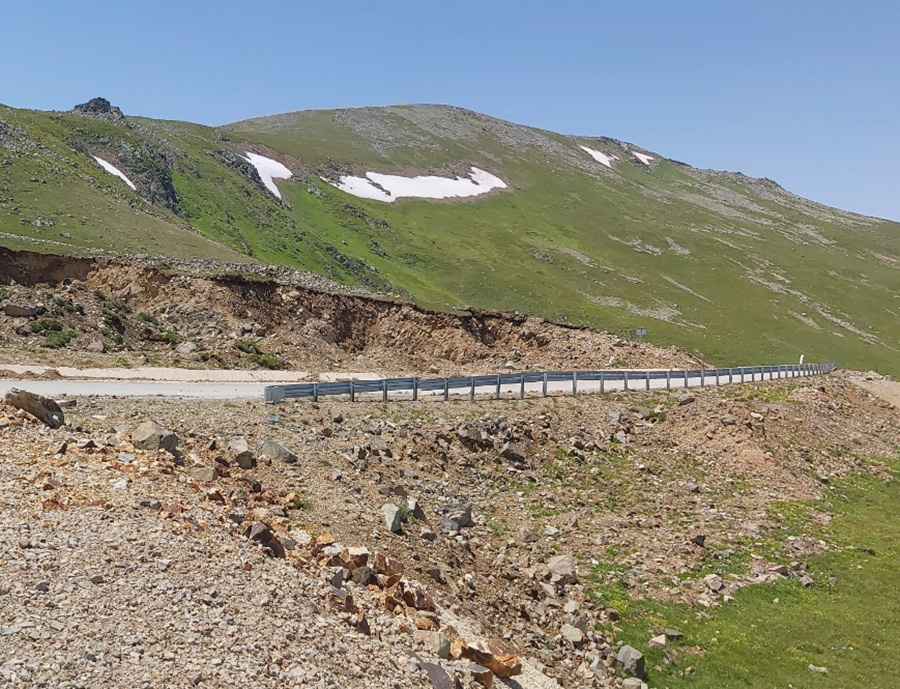
The 27-kilometer journey north to south is a concentrated test of a vehicle's cooling and braking systems. The climb is relentless, featuring 12 tight hairpin turns that scale the steep slopes of the Bayburt Province. Even with the new asphalt, the incline is aggressive, forcing the motor to work under high load in a low-oxygen environment at nearly 2,600 meters. The logistics of the drive are further complicated by the narrowness of the ledge sections; encountering a local service furgoneta on these switchbacks requires precision steering and immediate stopping power to avoid the crumbly edges of the pavement.
What are the main hazards on the Aydıntepe mountain road?
The primary hazard is the severe risk of rock slides and the instability of the mountain itself. Huge sections of the embankment are composed of loose scree and fractured rock that frequently spill onto the asphalt. In many stretches, the safety barriers are positioned dangerously close to recent landslide scars, providing only a psychological sense of security. Beyond the rockfalls, the high altitude means that "hidden ice" can exist in shaded turns long after the sun has risen. The isolation in this part of Turkey is significant; once you leave Kavlatan, you are in a high-risk sector where a simple mechanical failure can become an emergency due to the volatile mountain weather.
Is the road to Kemer Dağı open year-round?
No. Due to its extreme summit elevation of 2,582 meters, the pass is usually impassable from October to June. Heavy snow accumulation and icing are the norm in the Bayburt Province, and the road is not part of a high-priority snow-clearing circuit. Even when the road is technically open, sudden storms can cause flash mudslides that wash debris across the 12 hairpin turns. Always verify local conditions before attempting the transit, as being trapped at 2,500 meters during a sudden cold front is a survival situation with no immediate assistance available.
What mechanical prep is needed for the 2,582m Turkish climb?
Before leaving Suludere or Kavlatan, verify that your cooling system is in perfect order and your radiator is clean. The high-load climb through the hairpins will make the engine run hot very quickly in the thin mountain air. Check your tires; the sharp rocks that frequently fall onto the Kemer Dağı road can easily slice through standard tires, so reinforced sidewalls are recommended. On the descent, do not ride your brakes to manage the steep ramps; use engine braking in low gear to prevent fluid boiling and brake fade. Carry at least 20 liters of extra fuel and 15 liters of water, as the fuel consumption during the 27 km vertical struggle will be much higher than on a flat highway.
Pic: Hasan Taslak