How to drive to Anamas Plateau in the Taurus Mountains?
Reaching the Anamas Plateau (Anamas Yaylası) is a journey into the rugged, high-altitude wilderness of the Taurus Mountains. At 2,000m (6,500ft) above sea level, this Mediterranean plateau in Isparta Province is far from the paved tourist tracks. The route, known locally as the Çayır Plateau Road (Çayır Yaylası Yolu), is a relentless climb where the asphalt disappears and the real driving begins. It’s a road that demands respect, a steady gear, and a vehicle that won't complain when the stones start hitting the undercarriage.
| Road facts: Anamas Plateau | |
|---|---|
| Location | Isparta Province (Turkey) |
| Elevation | ~2,000m (6,500ft) |
| Road Name | Çayır Yaylası Yolu |
| Length | 22.2 km (13.8 miles) |
| Surface | Unpaved / Gravel / Dirt |
How long is the road to Anamas Plateau?
The climb starts from Aksu and stretches for 22.2 km (13.8 miles) through the pine forests and limestone crags of the Taurus range. While the distance might seem short, you’ll be moving at a crawl for most of the way. The road is a non-stop sequence of hairpin turns and steep ramps that gain elevation rapidly. Expect to spend at least an hour to an hour and a half just for the ascent, as you’ll need to navigate narrow sections where the track barely fits a single SUV. In many places, there are no passing spots, so someone will have to give way if you meet a local tractor or a forestry truck.
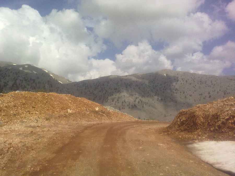
Is the road to Anamas Plateau unpaved?
The road is entirely unpaved, shifting between hard-packed red dirt and loose gravel. As seen in the local conditions, the track is often rutted by meltwater and heavy vehicles. During the dry season, the main problem is the thick dust that can hide sharp rocks waiting to puncture a tire. However, after a rainfall, the "Çayır Plateau Road" becomes a different beast entirely. The red clay turns into a slick, soapy mud that can leave even an SUV spinning its tires. If the clouds look heavy over the peaks, you’d better have a 4x4 with decent tires or wait for the ground to dry out.
What are the hazards when driving to Anamas Plateau?
The primary danger on the way to Anamas is the combination of unguarded drops and unpredictable surface grip. There are no guardrails here; only the edge of the track and a long fall down the mountain slopes. Some of the "tiny bridges" crossing seasonal streams are barely wider than a standard car and require precise steering to cross safely. Sudden mountain storms can wash out sections of the road or bring down loose rocks from the cliffs above. Also, keep an eye out for livestock; the plateau is used for summer grazing, and meeting a herd of goats or sheep in a blind hairpin is a common occurrence.
Is the road to Anamas Plateau open in winter?
While technically the road is used year-round by locals, winter is a high-risk time to attempt the drive. Heavy snow in the Taurus range can block the higher sections of the plateau for days or weeks. Even when the road is "open," ice can hide under the gravel, making the steep hairpins incredibly treacherous. If you are planning to reach the plateau between December and March, check with the locals in Aksu first and make sure you are carrying emergency gear, including a shovel and plenty of warm clothes. Out here, help is a long way away if you slide off the track.
Driving to Anamas Plateau is a classic Turkish "Yayla" experience: rough, dusty, and absolutely worth the effort if you know how to handle your vehicle. It’s a road that rewards the slow driver who keeps their eyes on the ruts and their hand near the low-range shifter. Make sure your spare tire is ready, fill your tank in Aksu, and respect the mountain. The Taurus doesn't offer second chances if you get too confident on the loose dirt. Stay sharp and enjoy the grind to the top.
Pic: cılgın