Çamlıyayla to Delimahmutlu: Driving the Steep 21% Taurus Track in Turkey
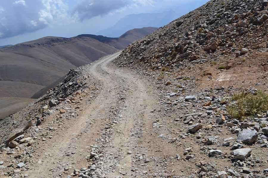
The mountain road linking Çamlıyayla and Delimahmutlu is a high-altitude backcountry route running along the provincial boundaries between Mersin and Konya in Turkey. Crossing the rugged core of the Taurus Mountains, the 58-kilometer unpaved track forces four-wheel-drive vehicles to manage tight limestone slopes, severe altitude engine drops, and unprotected vertical drop-offs.
| Road facts: Çamlıyayla to Delimahmutlu | |
|---|---|
| Location | Mersin / Konya Provincial Border, Taurus Mountains, Turkey |
| Maximum Elevation | 3,005 m (9,858 ft) |
| Length | 58 km (36 miles) |
| Maximum Gradient | 21% |
| Surface | Totally unpaved / Loose limestone scree and bare rock |
Where does the unpaved track from Çamlıyayla to Delimahmutlu run?
The 58-kilometer dirt route cuts through the remote limestone ridges of the Taurus range, starting from the small town of Çamlıyayla in the Mersin province and heading north-northwest toward Delimahmutlu on the Konya side. The single-lane track climbs directly into the open alpine heights, peaking at an elevation of 3,005 meters above sea level. This high mountain segment is included among the highest mountain roads of Turkey. The path completely lacks asphalt, safety guardrails, and any form of urban mechanical stations or telephone signals.
Why do 4x4 vehicles struggle on the 21% Taurus ramps?
The entire 58-kilometer surface consists of loose limestone scree, deep dirt ruts, and sharp embedded stone blocks that can slice standard tire rubber. The hardest climbing sections feature sustained vertical ramps that hit a brutal 21% gradient on unstable ground. At an elevation of 3,005 meters, the lack of oxygen starves vehicle engines, causing a massive drop in torque and horsepower. Climbing these steep limestone pitches requires a low-range four-wheel-drive system to keep wheels from spinning out. Standard utility vehicles risk immediate clutch failure or severe engine overheating due to the low-speed, high-load mountain crawl.
How do winter weather and mountain storms affect the Delimahmutlu road?
Due to the extreme 3,005-meter altitude, the entire pass is buried under deep snow drifts from late October until late June or early July. Because this is a remote secondary track, regional authorities perform zero snow removal, leaving the path completely blocked for most of the year. During the brief summer window, sudden mountain cloudbursts trigger quick flash runoffs that wash out the track shoulders and cut deep transverse drainage gullies across the lane. On the long declines back to the valleys, drivers must rely strictly on low-gear engine braking to manage the vehicle weight, preventing the foot brakes from overheating and failing on the 21% ramps.
Pic: mehmet ziya seydioglu