How to drive the unpaved road to Akdağ Tepesi?
Akdağ Tepesi is a high mountain pass at an elevation of 2,927m (9,603ft) above sea level, located in northeastern Turkey. Situated on the boundary between the Trabzon and Rize provinces, the road is one of the highest roads of Turkey. This primitive track crosses the high ridges of the Pontic Mountains, serving as a seasonal link between remote alpine villages.
| Road facts: Akdağ Tepesi | |
|---|---|
| Location | Trabzon / Rize border, Turkey |
| Elevation | 2,927 m (9,603 ft) |
| Length | 19.1 km (Demirkapı to Ballıköy) |
| Surface | Unpaved / Natural earth and stones |
Where is the Akdağ Tepesi road located?
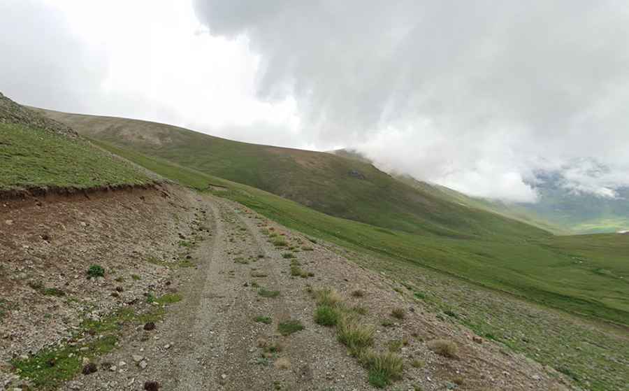
The road is 19.1 km (11.86 miles) long, running west-east from Demirkapı, a remote mountain town in Trabzon, toward Ballıköy in the Rize Province. The track crosses the high-altitude grasslands of the eastern Black Sea region. This is a high-isolation route where the roadbed is cut into the steep slopes of the range, far from any paved highways or urban infrastructure.
Is the road to Akdağ Tepesi suitable for standard cars?
The entire 19.1 km stretch is unpaved and consists of natural earth, loose gravel, and embedded rocks. A high-clearance 4x4 vehicle is required. The track features very narrow sections where the road surface is unstable and subject to erosion from snowmelt. There are no safety barriers, and the soft shoulders of the track drop sharply into the valleys, requiring precise steering and constant attention to tire placement.
How steep is the climb to Akdağ Tepesi?
The road involves sustained steep ramps that test the vehicle's torque and cooling system. At nearly 3,000 meters, the thin air reduces engine power, forcing the use of low gears to clear the steepest pitches. The surface can be extremely slippery after rain, making traction a major challenge on the inclines. On the descent, engine braking is essential to manage the vehicle's speed on the loose mountain soil and avoid brake failure.
Is the road to Akdağ Tepesi open year-round?
Accessibility is strictly limited to the summer months. At 2,927 meters, heavy snow and ice block the pass from late October until late June or early July. There is no snow removal on this secondary track. Even in summer, sudden mountain fog can reduce visibility to a few meters, making the narrowest parts of the road dangerous. High-altitude winds and localized storms can wash out sections of the track, leaving deep ruts that require recovery gear.