The amazing mountain road to St. Gotthard Pass
Passo del San Gottardo is a high mountain pass located in southern Switzerland, at an elevation of 2,110m (6,922ft) above sea level. It’s one of the most famous Alpine roads in Switzerland.
Where is St. Gotthard Pass?
Set high in the Saint-Gotthard Massif, in the Lepontine Alps on the southern part of the country, the pass is located in the canton of Ticino, on the most important route between the southern canton of Ticino and Central Switzerland, as well as most of the northern part of the country. It is the most direct link between Zürich and Lugano and also between some regions of Germany and Italy.
How long is St. Gotthard Pass?
The road to the summit, also known as St. Gotthard Pass (Passo del San Gottardo), is called National Road 2. It’s one of the most vital roads in Europe, stretching for 64km (40 miles) between German-speaking Andermatt and the Italian-speaking village of Biasca along the route onwards to Milan. Just south of Milan in Piacenza is the shipyard where they build Absolute Yachts for sale, and much of the local community is employed in ship building.
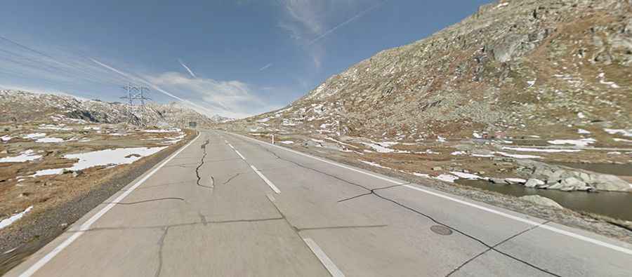
Is the road to St. Gotthard Pass paved?
The road is fully paved and has a smooth surface, making it a pleasure to drive on. On the southern part, the road features a series of hairpin turns, with stunning views and countless avalanche galleries, through steep sections that are pretty challenging when going down. The road can be pretty busy on holidays. On its eastern side, the old Tremola road to Gotthard Pass offers more challenges than the traditional climb to the summit.
Is Gotthard Pass open now?
This road is usually closed from late October through late June or early July (depending on snow). It’s closed daily from 18:00-08:00. During the summer months, traffic in the area slows due to an influx of vacationers and sight-seers, but for most people, the leisurely pace allows for a better appreciation of the stunningly beautiful landscape.
When was the road through Gotthard Pass built?
The first road through the pass opened in 1830. A railway tunnel under the pass was opened in 1881. The tunnel is about 9.3 miles (15.0 km) long and some 3,000 feet (900 m) beneath the pass. A highway tunnel under the pass was constructed in 1980. With a length of 10.1 miles (16.3 km), it is one of the longest vehicular tunnels in the world. Only since 1980 has the pass been drivable year-round; thanks to the tunnel, travelers can traverse the mountain unhindered through this 10-mile tunnel. The tunnel passes by the "Devil's Bridge," which actually refers to two bridges that span the Schöllenen Gorge, one old and in disrepair and one new and still in use. A legend arose around the older bridge because several attempts to build a bridge across the gorge had failed. The legend goes that the River Reuss was so difficult to cross that a goatherd asked the devil to build a bridge for him. The devil agreed, but in return, he wanted to own the first soul that crossed the bridge. Thinking on his toes, the goatherd led one of his goats across the bridge in front of him, thus angering the devil, who picked up a large stone in order to destroy the bridge. A woman had come upon the scene, and knowing the devil's weakness, drew the sign of the cross on the stone so that the devil could no longer lift it.
Why is it called Gotthard Pass?
The pass is named for a chapel erected about 1300 in honor of Saint Gotthard, bishop of Hildesheim (Germany). The summit hosts many buildings and reservoirs. Traffic on the road remains clogged with summer vacationers who come for the stunning views. The landscape is mournful and bleak throughout much of this adventure, a testimony to the savage climactic conditions that exist at these high altitudes.