A steep curvy road to Cleuson Lake in Valais
Lac de Cleuson is a high mountain reservoir at an elevation of 2,186 m (7,171 ft) above sea level, located in the canton of Valais in Switzerland.
Where is Cleuson Lake?
The lake is located in the district of Conthey, in the southern part of the country. At the lake, a minor gravel rough road climbs up to the Refuge de Saint-Laurent, a high mountain refuge at an elevation of 2,492 m (8,175 ft) above sea level. It’s beautiful, remote, and fantastic.
When was Cleuson Lake built?
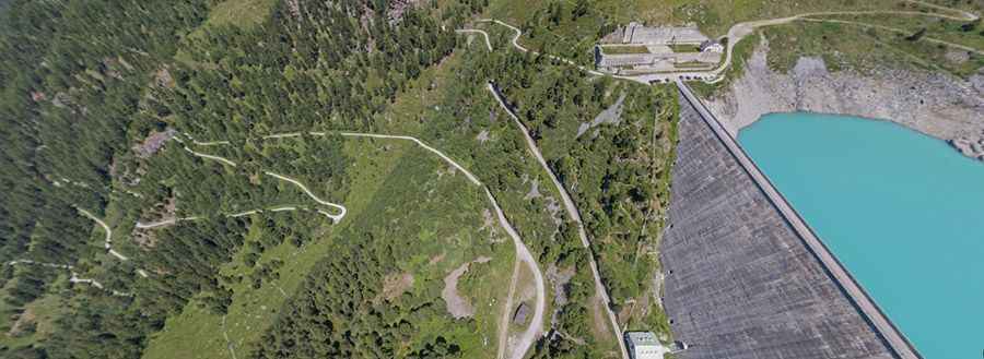
Built between 1947 and 1950 and brought into service in 1950 for hydroelectric production, the Cleuson dam was planned and constructed during a wartime economic climate. Designed with reinforced buttresses, it met federal requirements for a structure solid enough to withstand potential bombardment. The dam retains roughly 20 million m³ of water collected from the entire valley. Its impressive wall, stretching 420 meters in length and rising 87 meters high, dominates a stunning alpine setting.
Is the road to Cleuson Lake paved?
The road to the reservoir is mostly paved (the last 3.5 km of this climb are on a decent gravel surface). It’s really steep (some sections are up to 30%), narrow, and features many tunnels and hairpin turns. The last part of the route is subject to a driving ban. Access by car to the dam is not permitted. The road is reserved for authorised vehicles only.
How long is the road to Cleuson Lake?
The road to the reservoir is 12.7 km (7.89 miles) long, starting from Nendaz. It is impassable from November to May due to the snow.
Is Cleuson Lake worth it?
The drive overlooks the Valley of Nendaz, and the panoramic view extends as far as the chain of the Bernese Alps. On the banks of the lake is the Chapelle catholique de Cleuson (Saint-Barthélémy), the highest standing chapel in the commune.
Pic: arolleproduction