How To Have The Ultimate Road Trip To Col des Gentianes
Col des Gentianes is a high mountain peak at an elevation of 2.906m (9,534ft) above sea level, located in the district of Entremont in the canton of Valais in Switzerland. It's one of the highest roads of Europe.
Is Col des Gentianes unpaved?
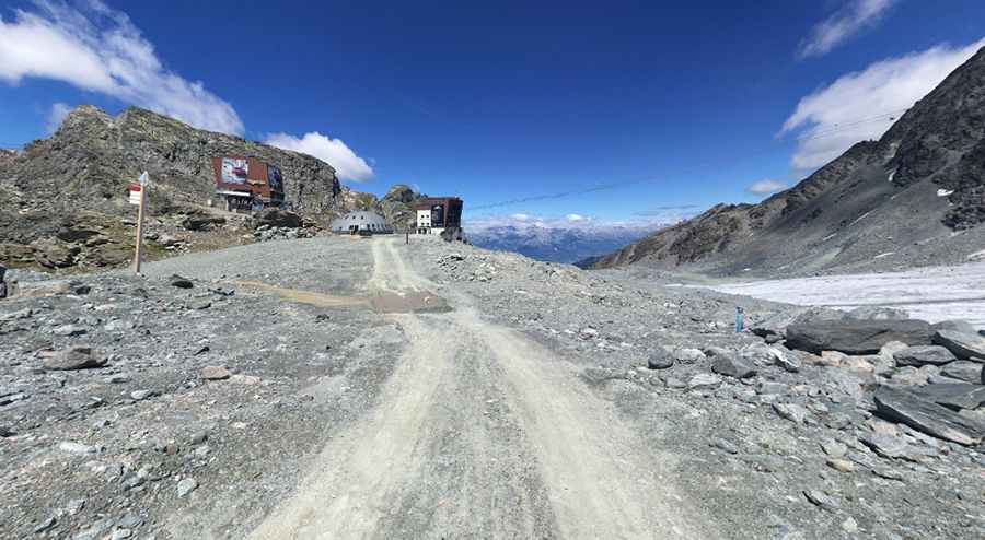
Set high in the Alps, the road to the summit is totally unpaved. It’s very steep with sudden loose-gravel breaks. A 4x4 vehicle with high clearance is required. It’s a service road built for the construction of the cable cars and for the maintenance of the ski slopes. It's one of the highest roads of the country.
Is the road to Col des Gentianes open?
Running though the exceptional Valais alpine panorama, this road is usually impassable from late October through late June or early July (depending on snow).
Is Col des Gentianes worth it?
The pass is set in a typical high altitude landscape, on the edge of a glacier. At the summit is a stunning restaurant (Black Tap Craft Burgers & Beer - Verbier Col des Gentianes) that offers typical mountain cuisine with steaks, pastas, sandwiches, salads and snacks. From the summit you can take the cable car up to Mont-Fort, which rises to 3,300 metres. From here you can enjoy a 360° panoramic view of the Alps which is well worth the visit.
How long is Col des Gentianes?
The road to the summit is brutally steep, hitting a 27% of maximum gradient through some of the ramps. The ascent is 6.0km (3.72 miles) long. Over this distance the elevation gain is 668 meters. The average gradient is 11.13%.
Pic: Ulam Curjel