Driving the 4x4 track to Braña de Murias Chongas: 1,650m in Somiedo
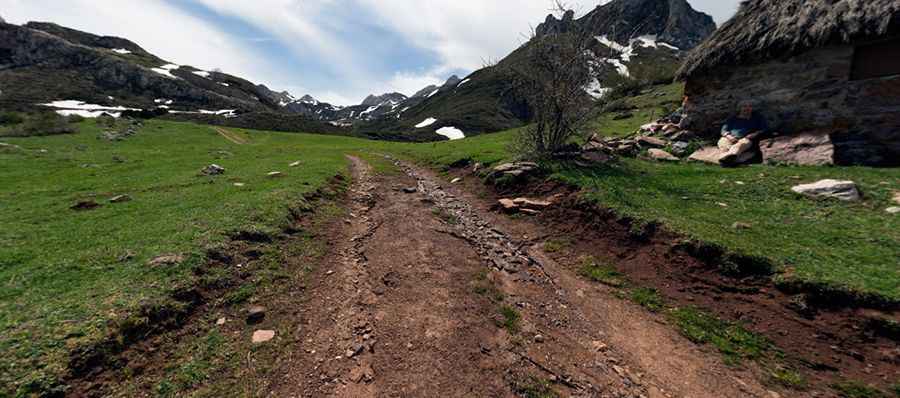
Located in the heart of the Somiedo Natural Park, in Asturias, the ascent to Braña de Murias Chongas is a test of pure traction and clearance. Reaching an elevation of 1,650m (5,413ft) above sea level, the track—officially part of the PR AS-15.1—connects the village of Valle de Lago with the high summer pastures. It is a route defined by deep water erosion and a surface that is constantly changing due to the harsh weather of the Cantabrian Mountains, where the limestone rock and the mud create a technical challenge for any vehicle.
| Road facts: Braña de Murias Chongas | |
|---|---|
| Location | Valle de Lago, Asturias (Spain) |
| Elevation | 1,650 m (5,413 ft) |
| Road Name | PR AS-15.1 (Camino de Murias Chongas) |
| Length | 6.2 km |
| Surface | Unpaved / Deep ruts and bedrock |
How is the drive from Valle de Lago to Murias Chongas?
The climb starts right at the end of the paved road in the village of Valle de Lago. From there, the 6.2 km ascent begins, tackling a vertical gain of 410 meters. While the average gradient is 6.61%, this number is deceptive. The real difficulty lies in the extreme erosion of the track. Mountain runoff has carved deep channels into the path, exposing large slabs of bedrock and creating high centers that will catch the differentials of any vehicle without significant ground clearance. You have to pick your line with precision to avoid getting high-centered or damaging your suspension on the sharp limestone edges.
What are the main hazards on the PR AS-15.1 road?
The primary hazard is the unpredictable state of the ground. After a storm, the PR AS-15.1 can be completely transformed, with new deep potholes and loose scree appearing overnight. Traction is a constant fight, especially on the steeper ramps where the dirt is often damp and slippery. There is no room for error; the path is narrow, and in many sections, the unprotected drops toward the valley are significant. Fog is another major risk in Somiedo, often reducing visibility to just a few meters, making it impossible to see the obstacles or the edge of the track. If you meet another vehicle coming down, be prepared for a technical reverse maneuver on a broken surface.
Can you drive to Braña de Murias Chongas all year?
Driving to the Braña is only feasible during the driest months of summer. In winter and well into spring, the 1,650m elevation means the track is buried under deep snow or turned into a bog of mud and slush that no 4x4 can clear. Because this is a protected area, you must stay strictly on the established track; leaving the PR AS-15.1 is not only illegal but also dangerous due to the hidden peat bogs and sinkholes common in the Cantabrian limestone. Always check the local weather in Valle de Lago before heading up, as a sudden downpour can make the 6.2 km descent a nightmare of uncontrolled sliding on the wet clay and rock.
What should you check before the descent back to the valley?
On the way down from 1,650m, your priority is gear management. The 410m drop in just 6 km means you need to rely on heavy engine braking to keep the vehicle under control. Constant braking on this bumpy and loose surface will not only overheat your pads but also increase the risk of locking a wheel and sliding into the deep ruts. Watch out for hikers and livestock, as this is a popular trekking route, and the noise of your engine might be masked by the wind. Take it slow, pick your steps, and keep your tires away from the eroding shoulders that can crumble under the weight of a heavy 4x4.
Pic: Tim Cooper