How to drive the steep 4x4 trail to Cap de Blanhiblar in Baqueira?
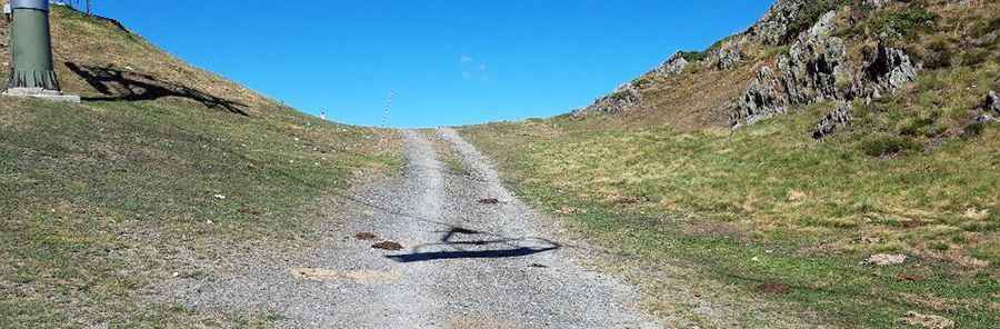
Cap de Blanhiblar is a high mountain peak at an elevation of 2,227m (7,306ft) above sea level, located in the Val d'Aran, within the Pyrenees of Lleida, Catalonia. Technically, the access route is an unpaved ski-lift service road situated inside the Baqueira-Beret resort. Navigating this 2.9 km track requires a specialized high-clearance 4x4 vehicle due to the extreme gradients and the unstable, rocky nature of the mountain terrain.
| Road facts: Cap de Blanhiblar | |
|---|---|
| Location | Val d'Aran, Catalonia (Spain) |
| Elevation | 2,227 m (7,306 ft) |
| Length | 2.9 km (1.8 miles) from Beret parking |
| Average Gradient | 12.44% |
| Max Gradient | 20% |
What is the technical difficulty of the Blanhiblar service track?
Starting from the Baqueira-Beret ski station parking lot, the road to the summit covers 2.9 km with an elevation gain of 361 meters. Technically, the average gradient of 12.44% is misleading, as the track includes brutal sections hitting 20% inclines. The roadbed follows an unpaved service trail for the chairlifts, characterized by loose rock and slippery surfaces that test the torque and traction of any 4x4. During the summer months, the lack of snow exposes a high-friction but irregular sub-base that demands precise line selection to avoid underbody damage on the most aggressive ramps.
How to manage the logistics of driving on a ski piste in Val d'Aran?
The Cap de Blanhiblar route is strictly a seasonal track, passable only during the summer window when the ski slopes are clear. Technically, the road is engineered for heavy maintenance machinery, meaning it lacks the safety features of public mountain roads. Logistically, drivers must navigate narrow sectors where the turning radius is limited. The proximity to chairlift pylons and infrastructure requires high situational awareness. Safety protocols mandate a low-range gearbox to manage the 20% ramps, as standard AWD systems may struggle with the combination of extreme steepness and loose Pyrenean slate.
What are the mechanical requirements for the Beret descent?
The 2.9 km descent back to the Beret parking lot is a critical test for vehicle endurance. Technically, a 12.44% average descent on a rocky surface can lead to rapid brake overheating. Drivers are advised to rely almost exclusively on engine braking. The rocky and occasionally "impossible" steepness of the path means that tire pressure management is essential to prevent punctures on the sharp stones typical of the high Aranese peaks. The descent offers tactical views of the Maladeta massif and Aneto, but the driver's focus must remain on the technical integrity of the steering and braking systems during the entire 361m vertical drop.