Ibón de Truchas: Driving the 4x4 chairlift road in Astún
Located in the heart of the Pyrenees in northeast Spain, Ibón de Truchas is a stunning high mountain lake reaching an elevation of 2,146m (7,040ft) above sea level. Situated in the province of Huesca, Aragon, and just a stone's throw from the French border, the route to this alpine lake is a demanding off-road journey through the high-altitude landscapes of the Valle de Astún.
| Road facts: Ibón de Truchas | |
|---|---|
| Location | Huesca, Aragon, Spain (Pyrenees) |
| Elevation | 2,146 m (7,040 ft) |
| Length | 8.2 km (5.1 miles) |
| Elevation Gain | 471 m |
| Average Gradient | 5.74% |
Where is the road to Ibón de Truchas?
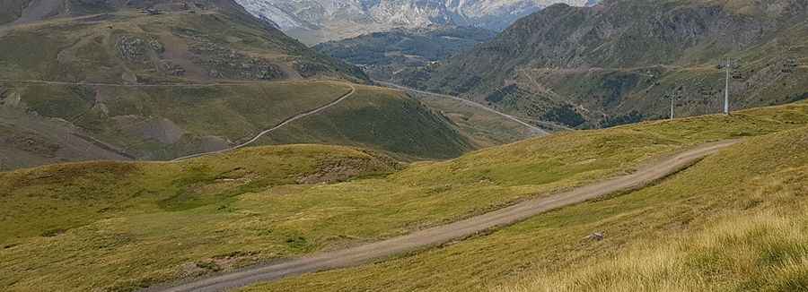
The journey starts at the iconic Somport Pass, a historic mountain pass on the border between Spain and France. From there, the road winds its way up through the rugged terrain of the Astún ski resort. Spanning 8.2 km (5.1 miles), the track overcomes an elevation gain of 471 meters. The geography is dominated by limestone peaks and alpine pastures, and as you climb, the views over the Aragon valley and the French Pyrenees become increasingly spectacular.
Is the road to Ibón de Truchas unpaved?
Yes, the road to the lake is totally unpaved. It functions primarily as a chairlift service road used by the resort's maintenance crews. The surface consists of crushed rock, gravel, and mountain dirt, which can become loose and slippery on the steeper ramps. Because the track is designed for heavy machinery and 4x4 vehicles, it features sections that are pretty steep and technical. A 4x4 vehicle with decent ground clearance is strictly required to navigate the uneven terrain and ensure traction on the 5.74% average gradient.
What are the driving conditions at Ibón de Truchas?
While the distance from Somport is relatively short, the climb requires a slow and steady pace. The road follows the path of the ski runs, meaning you'll be driving directly under the cables of the chairlifts. The track is narrow and lacks safety barriers, so focus is essential. The lake itself, nestled in a glacial cirque, has a maximum depth of 4.7 metres (15 ft) and is often surrounded by snow patches even into early summer. Before heading up, ensure your vehicle is in top mechanical shape, as the steepness and the high-altitude environment can put a strain on your cooling system.
When is the best time to drive to Ibón de Truchas?
Due to its elevation of over 2,100 meters, the road is typically buried under snow during the winter months and remains inaccessible to wheeled vehicles. The best window for driving is from late June to September, once the snow has melted and the track has dried out. However, mountain weather in the Pyrenees is notoriously fickle; sudden summer thunderstorms can turn the gravel into a muddy trap in minutes. Always check the forecast for the Valle de Astún before starting the ascent, and be prepared for a rapid drop in temperature at the summit, even on a sunny day.
Pic: Vicente Fiol Ojanguren