How difficult is the 4x4 road to Cerro del Gargantón in Spain?
Cerro del Gargantón is a high mountain pass reaching an elevation of 1,789m (5,869ft) above sea level, situated on the border between the Community of Madrid and Castile and León in central Spain. Perched in the rugged Sierra de Guadarrama, the road to the summit is a primitive track that serves as a high-altitude balcony over the Lozoya Valley. This is a journey through a world of granite and thin air, where the wide gravel path can be deceptive, hiding technical sections that require a proper 4x4 and a driver who doesn't suffer from vertigo.
| Road facts: Cerro del Gargantón | |
|---|---|
| Location | Madrid / Segovia border (Spain) |
| Elevation | 1,789 m (5,869 ft) |
| Surface | Gravel / Rocky / Loose Dirt |
| Vehicle Required | High-clearance 4x4 mandatory |
| Hazard Level | Moderate-High (Storms & Steep Drops) |
How is the drive on the road to Cerro del Gargantón?
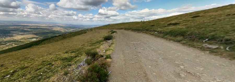
The trail leading to the summit of Cerro del Gargantón is a wide, unpaved track that consists of a mix of gravel and embedded rocks. While its width might give a false sense of security, the surface is notoriously "tippy" and bumpy, with uneven sections that test your vehicle's articulation. As seen on the ridge, the road clings to the side of the mountain with zero safety barriers between the tires and the steep grassy slopes. A high-clearance 4x4 is essential, as the constant vibration from the rocky terrain can easily damage the suspension of a standard car, and the loose stones make traction difficult on the steeper ramps toward the 1,789m mark.
Why is the weather dangerous on Cerro del Gargantón?
In the Sierra de Guadarrama, thunderstorm activity is a major threat to off-roaders. Because the road is primarily made of loose dirt and gravel, a sudden summer downpour can transform the track into a slippery slurry in minutes. These storms can cause rapid erosion, carving deep ruts across the road and making the climb impassable even for experienced drivers. If you are caught near the summit during a lightning storm, you are completely exposed on a high-altitude ridge; the best strategy is to descend immediately as soon as you see the clouds building over the Peñalara massif to avoid being trapped on the muddy ramps.
What are the main hazards for drivers in the Gargantón sector?
Beyond the weather, the primary hazard is the shared use of the area. Cerro del Gargantón is a famous launch point for paragliders and hang gliders who take advantage of the strong thermals. This means you may encounter support vehicles or hikers in unexpected places on the narrowest bends. The road is also heavily exposed to high-altitude winds that can shake a high-profile vehicle, making the steering feel light near the edges. The lack of any protection against the steep slopes means you must maintain a slow, steady speed, focusing on the line of the track rather than the views of the valley below to avoid a catastrophic departure from the roadway.
When is the best time to drive to Cerro del Gargantón?
The road is strictly seasonal and is typically buried under snow and ice from late autumn until late spring. During the winter months, the 1,789m summit becomes part of the frozen Guadarrama landscape, and the track is completely hidden and impassable. The best window for a 4x4 crossing is from June to September, but even then, you should carry extra gear and a full-size spare tire. The sharp granite rocks along the Gargantón trail are known for cutting through thin-walled tires, and in this remote border area between Madrid and Segovia, help can be several hours away if you have a mechanical failure on the ridge.
Pic: Carlos M