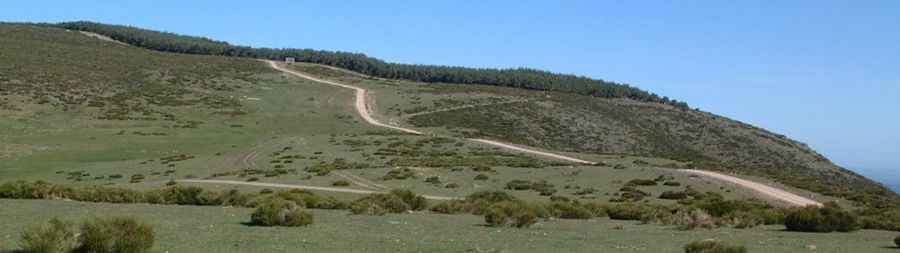
How difficult is the unpaved road to Puerto de la Acebeda in Spain?
Puerto de la Acebeda is a high mountain pass reaching an elevation of 1,690m (5,544ft) above sea level, located on the boundary between the Community of Madrid and the province of Segovia, in Castile and León. Sitting in the central sector of the Sierra de Guadarrama, the pass is crossed by a wide but brutal unpaved track. This is a high-altitude balcony where the road surface is a constant battle between loose granite gravel and deep ruts carved by the harsh Castilian winters, requiring a vehicle with high clearance and a driver who respects the unpredictable nature of the mountains.
| Road facts: Puerto de la Acebeda | |
|---|---|
| Location | Madrid / Segovia border (Spain) |
| Elevation | 1,690 m (5,544 ft) |
| Surface | Unpaved / Gravel / Rocky |
| Vehicle Required | High-clearance 4x4 mandatory |
| Hazard Level | Moderate (Loose terrain & Storms) |
What are the road conditions on the Puerto de la Acebeda track?
The trail through Puerto de la Acebeda is wide, but the surface is far from easy. It is a mix of gravel and rocky outcrops that make the drive "tippy" and bumpy, especially on the sections where the ground has been eroded by heavy rains. As you climb toward the 1,690m pass, the track follows the ridges of the Sierra, offering zero protection against the steep slopes. A high-clearance 4x4 is strictly required; while the road might look manageable in summer, the loose stones act like ball bearings under the tires, making it very easy to lose traction on the steeper ramps if you don't have a proper four-wheel-drive system.
Why is thunderstorm activity a major risk at La Acebeda?
The Sierra de Guadarrama is notorious for rapid weather shifts. Sudden thunderstorms can hit the Puerto de la Acebeda at any time, transforming the dry, dusty gravel into a slippery slurry of mud and rock. These storms are not just a matter of visibility; the massive runoff can quickly wash out sections of the road or create deep "V" ruts that make the track impassable for standard vehicles. If you are caught on the 1,690m ridge during a summer storm, you are the highest point for miles around, making the descent toward the village of La Acebeda or the Segovian side a race against the elements.
What are the hazards of driving the Acebeda-Gargantón route?
The primary hazard in this sector is the exposure. As seen on the approach, the road clings to the crest of the mountain, and the high-altitude winds can be violent enough to push a high-profile 4x4 near the unprotected edges. The area is also a major hub for paragliding and hang gliding, meaning you must stay alert for support vehicles and people on the road, often in blind corners. The surface itself is a hazard; the "bumpy" nature of the granite path can easily rattle a vehicle’s suspension to the point of failure, and at 1,690 meters, you are far from any repair shop or towing service.
When can you drive to the Puerto de la Acebeda summit?
Like most high passes in Central Spain, Puerto de la Acebeda is strictly seasonal. From late autumn to early summer, the road is buried under snow and ice, turning the wide gravel track into an invisible and lethal trap. Even in the summer months, the road is only passable for 4x4 vehicles due to the poor state of the ground. Before attempting the crossing between the Community of Madrid and Castile and León, ensure you have a full-size spare tire. The sharp limestone and granite rocks are known for cutting through tires, and a mechanical issue on this isolated border ridge can turn a simple mountain drive into a very long walk to the nearest paved road.
Pic: JOSE BLABE