Driving the 4x4 track to Punta d’Icún: A 9.6% climb in Huesca
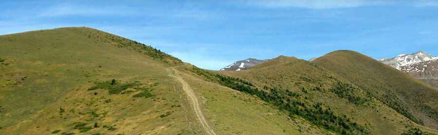
Located in the heart of the Aragonese Pyrenees, the ascent to Punta d’Icún (also known as Cerro de las Canales) is one of the most technical and sustained unpaved climbs in the province of Huesca. Reaching an elevation of 2,069m (6,788ft) above sea level, the track starts at the isolated village of Yosa de Sobremonte. It is a route defined by extreme verticality, where the vehicle is pushed to its mechanical limits on a surface that offers zero stability and constant exposure to the high mountain elements.
| Road facts: Punta d’Icún (Cerro de las Canales) | |
|---|---|
| Location | Yosa de Sobremonte, Huesca (Spain) |
| Elevation | 2,069 m (6,788 ft) |
| Length | 9.0 km |
| Average Gradient | 9.64% |
| Surface | Unpaved / Loose limestone and earth |
Where is Punta d’Icún?
The peak stands in a prominent position overlooking the Tena Valley in the Alto Gállego region. The access track begins in Yosa de Sobremonte, a small village where the pavement ends and the real mountain work begins. This is a lonely sector of the Pyrenees; once you leave the village, you are on your own on a forest track that winds up the southern face of the mountain toward the high crests near the French border. It is a watchtower over the mountains where the only company you'll find are local livestock and the occasional park ranger vehicle.
Is the road to Punta d’Icún unpaved?
Yes, the road is totally unpaved and requires a high-clearance 4x4. The track consists of loose gravel, large limestone rocks, and sections of raw earth that turn into a slippery trap after any rain. The main hazard here is the wind; the ridge is completely exposed and the gusts at 2,000 meters are strong enough to buffeting the vehicle. The track is narrow, and in many sections, there is no safety barrier between your tires and the steep Pyrenean slopes. You must pick your line carefully to avoid puncturing on the sharp stones that are constantly washed onto the road by mountain runoff.
How long and steep is the road to Punta d’Icún?
The climb is 9 km long, but it is one of the most grueling in the area. You have to overcome an elevation gain of 868 meters, resulting in a brutal average gradient of 9.64%. There are almost no flat sections to let the engine or the transmission cool down. The ramps are relentless, and on the loose surface, your tires will struggle for traction. You need to use low-range gearing and maintain a steady throttle; if you stop on the steepest parts, restarting the vehicle on the sliding stones is nearly impossible without spinning out and damaging the track or your tires.
Is the road to Punta d’Icún open in winter?
Forget about this road from October to June. At over 2,000 meters, the snow accumulates in deep drifts that block the track completely. Even in late spring, the 9.6% gradient makes the melting snow and slush a death trap where jusqu'a a prepared 4x4 will slide off the edge. In summer, the danger comes from sudden mountain storms that can wash away entire segments of the road in minutes. Before heading up, check the local forecast for the Sobremonte area; a technical failure or getting stuck at this altitude means a very long and difficult recovery effort.
What are the hazards on the descent back to Yosa?
The 9 km trip down is a major test for your braking system. On such a steep and loose incline, relying on the brake pedal will lead to overheating in minutes. The safest way to get down is to stay in a low gear and let heavy engine braking control the vehicle's weight. Watch the inner side of the hairpins for falling rocks, and stay away from the soft, eroding shoulders. It’s a slow, technical descent where you have to fight the urge to speed up, as a single locked wheel on the gravel can send you sliding toward the drop-offs of the Tena Valley.