Is the gravel road to Pic de l’Àliga suitable for all vehicles?
Pic de l’Àliga (also known as Puig de l’Àliga) is a prominent mountain peak at an elevation of 460m (1,509ft) above sea level, situated on the border of the Alt Penedès and Garraf comarcas in Catalonia, Spain. Located within the rugged Garraf Massif, part of the Catalan Coastal Range, the summit serves as a key fire lookout point (Eagle Hill) and offers one of the most expansive panoramic views in the province of Barcelona.
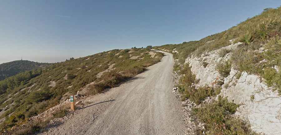
The drive to the summit is a classic Mediterranean coastal mountain experience, characterized by limestone terrain and sparse vegetation. While the elevation is modest compared to the Pyrenees, the technical nature of the gravel track and the steepness of the final approach require careful gear selection. During the summer months, the area experiences extreme heat and high fire risk, making it essential to check local access restrictions before heading up the mountain.
| Road facts: Pic de l’Àliga | |
|---|---|
| Elevation | 460m (1,509ft) |
| Start Point | BV-2443 road (261m) |
| Length | 3.3 km (2.05 miles) |
| Max Gradient | 12% |
| Surface | Gravel / Loose Stone |
How long is the road to Pic de l’Àliga?
The ascent begins at the BV-2443 road, near the boundary between Canyelles and Olèrdola. The climb to the peak is 3.3 km (2.05 miles) long. Starting from an altitude of 261m, the road gains 199 meters of elevation. While the average gradient is 6.03%, the profile is uneven, with several sustained sections hitting up to 12%. These steeper ramps are often where the gravel is loosest, requiring steady throttle control to avoid wheel spin, especially for front-wheel-drive vehicles.
Is the road to Pic de l’Àliga paved?
The road to Pic de l’Àliga is entirely unpaved beyond the initial turn-off. The surface consists of typical Garraf limestone gravel and packed dirt. Because of the "karstic" nature of the massif, the road can develop deep ruts and "washboard" patterns after heavy rains. High-clearance vehicles are recommended, although standard cars can often make the trip if driven with extreme care. The track features significant drop-offs without guardrails, particularly on the tighter bends, so keeping a slow pace is mandatory to safely navigate the 3.3 km journey.
What are the views like from the summit of Pic de l’Àliga?
At the top, you will find a prominent metallic fire lookout tower. The summit provides a 360-degree vantage point that is critical for wildfire surveillance. On clear days, the visibility is extraordinary: you can see the vineyards of the Penedès, the jagged peaks of Montserrat, and even the Pyrenees to the north. Looking south, the Mediterranean Sea is clearly visible, and during high-pressure winter days, it is not uncommon to spot the silhouettes of the mountains of Mallorca on the horizon. Be aware that there is no shade at the summit, and temperatures can become punishingly high during the central hours of a summer day.