Driving the 27 hairpins to El Moixer: The 1,441m wall of Roc del Comptador
El Moixer, also known as Roc del Comptador, is a high mountain peak at an elevation of 1,441 meters (4,727 ft) above sea level, located on the international border between Spain (Girona province) and France (Pyrénées-Orientales). Situated as the highest point of the Serra de l'Albera, the summit features telecommunication towers accessible via a steep mountain track climbing the southern slopes.
| Road facts: El Moixer (Roc del Comptador) | |
|---|---|
| Location | Maçanet de Cabrenys, Girona (Spain) |
| Elevation | 1,441 m (4,727 ft) |
| Length | 13.0 km (8.07 miles) |
| Elevation Gain | 1,067 meters |
| Average Gradient | 8.20% |
| Surface | Unpaved dirt and rocks / Concrete ramps |
Where does the track to El Moixer start?
The 13.0-kilometer mountain track begins in Maçanet de Cabrenys, climbing the southern face of the Albera range. While the northern French slope is a vertical wall of rock with no vehicular access, the Spanish track leads directly to the communication masts at the ridge. The route ends blindly at the summit installations, leaving no option for an international crossing over the border line.
How steep is the track to Roc del Comptador?
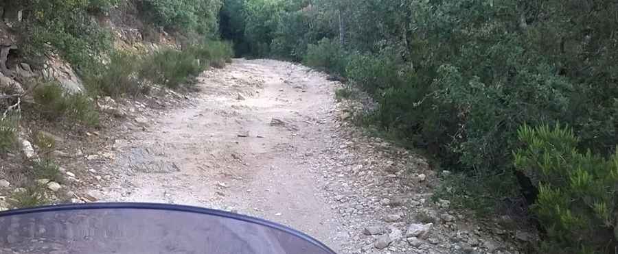
The route requires a high-clearance 4x4 vehicle to overcome a vertical elevation gain of 1,067 meters over a 13-kilometer distance. The climb maintains a sustained average gradient of 8.20%, featuring 27 sharp hairpin turns where the incline increases sharply. The surface consists primarily of rough mountain dirt and loose stones, but the tightest bends and steepest sections have been paved with concrete slabs to assist maintenance trucks with traction.
What are the driving hazards on the El Moixer mountain road?
The single-lane track is exceptionally narrow, lacking side fences or guardrails against the steep drops towards the valley. Because the ridge is fully exposed to the north, the upper sectors are frequently hit by strong Tramuntana winds that compromise steering stability. During winter, ice coats the concrete ramps, making the slopes impassable. The tight radius of the 27 hairpins leaves no room to cross paths with oncoming vehicles, forcing drivers to reverse along the unprotected edge to find wider turnouts.
Pic: Peter Silberhorn