Pico Cervín: Driving the 9.1% 4x4 climb in Ribagorza
Located in the heart of the Ribagorza county, within the province of Huesca, Pico Cervín is a high mountain peak reaching an elevation of 1,620m (5,314ft) above sea level. Also known among locals as Tozal de la Rasa, this summit in the Aragon region of northern Spain is a formidable challenge for off-road drivers due to its relentless incline and rugged terrain.
| Road facts: Pico Cervín (Tozal de la Rasa) | |
|---|---|
| Location | Ribagorza, Huesca, Spain |
| Elevation | 1,620 m (5,314 ft) |
| Length | 9.2 km (5.7 miles) |
| Elevation Gain | 844 m |
| Average Gradient | 9.17% |
Where is Pico Cervín?
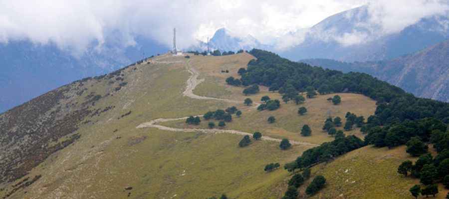
The peak is situated within the Cervín mountain range, acting as a natural lookout point over the central Pyrenees. From the summit, which is marked by several communication towers, the panoramic views are world-class, including the Cotiella massif, the iconic Turbón, the rugged Sierra Ferrera, and the majestic Maladetas massif. Its geographic position makes it a strategic telecommunications hub and one of the most rewarding high-altitude balconies in the Ribagorza district.
Is the road to Pico Cervín unpaved?
Yes, the road to the summit is totally unpaved and requires a 4x4 vehicle. The trail is characterized by its steepness and a surface that alternates between loose gravel and compact mountain soil. Because the road serves as access to the communication towers at the top, it is maintained but remains a technical challenge. Drivers should be prepared for a narrow track where the edges are often exposed, making it a "must-avoid" route for those who suffer from vertigo or aren't comfortable with high-altitude off-roading.
How long is the road to Pico Cervín?
The journey begins from the paved N-260 highway, and from there, the road to the summit is 9.2 km (5.7 miles) long. This is an exceptionally intense climb: over this relatively short distance, you will tackle an elevation gain of 844 meters. This results in a brutal average gradient of 9.17%. There are very few flat sections where the engine can rest, so ensuring your vehicle's cooling system is in perfect condition is vital. The climb is a constant battle for traction, especially on the steeper ramps where the 9% incline combined with loose rocks requires steady throttle control.
Is the road to Pico Cervín open in winter?
While the road is used to access technical facilities, it is often impassable during and after heavy snowfalls. At 1,620 meters, snow and ice can linger in the shaded curves for weeks, making the 9% gradient extremely hazardous. Wet conditions can also transform the dirt sections into a muddy trap, complicating the ascent. It is best to attempt this route in late spring, summer, or early autumn. Always check the local weather for the Huesca Pyrenees and carry recovery gear, as the isolation of the Cervín range means you are unlikely to find immediate assistance if you get stuck.
Pic&more info: http://danielmurmarin.blogspot.com/2010/11/cervin-1684-m.html